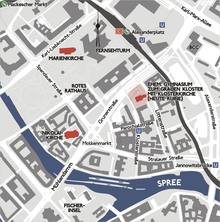
Franciscan Monastery Church (Berlin)

The Franciscan monastery church on Klosterstrasse in Berlin 's Mitte district is the ruin of a church that dates back to 1250.
At the site of today's ruins, the construction of a monastery church in the early Gothic style of a mendicant church for the gray monastery of the Franciscans began around 1250 . The field stone church was 52 meters long and 16 meters wide. Remains of it can still be found today in the northern wall of the ruin. The current construction - a three-aisled basilica with a seven-tenths choir closure - began at the end of the 13th century. In 1365, the Brandenburg Elector Ludwig d. J. von Bayern is buried here. Construction work on the brick church lasted until the first half of the 14th century. The building was renovated around 1500.
As a result of the Reformation introduced in Berlin in 1539 , the monastery was dissolved, of which no building apart from the church ruins has survived today. From 1571, the first Berlin printing company was located in the rooms of the former monastery. In 1574 the Berlinische Gymnasium zum Grauen Kloster was opened here. Famous students and teachers such as Karl Friedrich Schinkel , Friedrich Ludwig Jahn and Otto von Bismarck also visited the monastery church. Leonhard Thurneysser which also docked the print shop, the church had 1583/ 84 restored.
Small structural changes were made in the second half of the 17th century. The old stair tower was demolished and a new half-timbered staircase was built on the west side. 1712 in the central nave of the choir screen , which the chancel separated from the nave, demolished. In the same year there was a fire in the roof structure. Seven years later, restoration work was carried out, with the floor being raised by one meter and the two northern choir windows walled up.
Extensive renovation work was carried out in the first half of the 19th century. In 1826 the gable tower was removed; from 1842 two new towers were built on the west side; the floor was lowered again and a new sacristy was built. The construction work was preceded by various construction plans by Karl Friedrich Schinkel , Christian Gottlieb Cantian and the then superstructure inspector Wilhelm Berger . Only Berger's second plan was finally implemented. Construction work lasted until 1845.
Most of the changes made in the 19th century were reversed from 1926 after the church was closed from 1902 due to heavy moisture in the masonry. The new consecration took place on May 24, 1936.
The building was destroyed during the Second World War on April 3, 1945. From 1950 the rubble was removed and the ruins were secured from 1959 to 1963. The remaining monastery buildings, also in ruins, were completely demolished. The area around the church ruins was designed as a green space, on the other side of Littenstrasse the business building for part of the civil departments of the Berlin Regional Court and for the Central District Court as well as the headquarters of Hypoport AG border.
After another restoration in 2003/04, the ruin is currently used for exhibitions, theater performances and concerts.
See also
literature
- Landesdenkmalamt Berlin (Hrsg.): Church ruins of the gray monastery in Berlin. History, research, restoration (= contributions to the preservation of monuments in Berlin. Vol. 23). Michael Imhof Verlag, Petersberg 2007, ISBN 978-3-86568-200-0 .
- Gerhard Bronisch: The Franciscan Monastery Church in Berlin. In: Communications from the Association for the History of Berlin. Vol. 50, no . 4, 1933, ZDB -ID 3615-8 , pp. 89-142 , (at the same time: Leipzig, University, dissertation, 1933).
Web links
- Entry in the Berlin State Monument List with further information
- current page on the ruins of the Franciscan monastery church from the Department of Art and Culture of the BA Mitte
- Page to the church of the Förderverein Klosterruine e. V.
Coordinates: 52 ° 31 ′ 6 ″ N , 13 ° 24 ′ 46 ″ E


