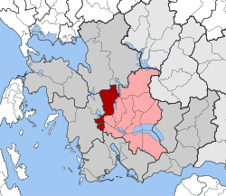
Stratos (Aetolia-Acarnania)
|
Stratos Municipality Δημοτική Ενότητα Στράτου (Στράτος) |
||
|---|---|---|
|
|
||
| Basic data | ||
| State : |
|
|
| Region : |
West Greece
|
|
| Regional District : | Aetolia-Acarnania | |
| Municipality : | Nafpaktia | |
| Geographic coordinates : | 38 ° 40 ′ N , 21 ° 20 ′ E | |
| Height above d. M .: | 40-100-201 m Ochthia, Stratos, Lepenou |
|
| Area : | 153,307 km² | |
| Residents : | 5,429 (2011) | |
| Population density : | 35.4 inhabitants / km² | |
| Code No .: | 380310 | |
| Structure: |
1 city district 7 local communities |
|
| Located in the municipality of Nafpaktia and in the Aetolia-Akarnania regional unit | ||
Stratos ( Greek Στράτος ( m. Sg. ), Latin Stratus ) is a village in Aetolia-Acarnania in the region of western Greece . Stratos is located immediately west of the Stratos reservoir named after him , which dams the Acheloos river , east of the village of Neapoli and northwest of the city of Agrinio and south of the city of Amfilochia . Stratos lies in the valley of the Acheloos and is surrounded by it south and south-east after passing the dam of the Stratos reservoir.
Under the name Sorovigli (Σωροβίγλι), the place was recognized as a rural community (kinotita) in 1912 , renamed in the ancient name Stratos in 1928 and raised to a town community (dimos) in 1997 when some neighboring communities were incorporated . On January 1st, this municipality was incorporated into the town of Agrinio , where it has since been a municipality.
Stratos has been settled since ancient times. Its location on the west bank of the Acheloos as a natural border between the regions of Aetolia and Acarnania gave it importance. The remains of the ancient settlement are still visible today and include a 7,000-seat theater, bouleuterion (meeting place) and a temple. In ancient times it was the most important city in the Aetolia-Acarnania region. After ancient times it lost its importance.
In 2005 the Acheloos flooded, which damaged buildings and agricultural areas.
The people of Stratos live mainly from agriculture. Stratos has a primary school, a high school and a lyceum. There is also a bank and a post office.
Stratos is connected to the public transport system via national road 5 ( European route 951 ); a connection to the Greek motorway system was started in 2007 with the construction of the Ionia Odos ( motorway 5 ).
Administrative division
| District local community |
Greek name | code | Area (km²) | 2001 residents | Residents 2011 | Villages and settlements |
|---|---|---|---|---|---|---|
| Stratos | Τοπική Κοινότητα Στράτου | 38031001 | 30,313 | 1107 | 979 | Stratos |
| Gouriotissa | Τοπική Κοινότητα Γουριωτίσσης | 38031002 | 15.774 | 676 | 395 | Gouriotissa |
| Kastraki | Τοπική Κοινότητα Καστρακίου | 38031003 | 24.262 | 470 | 419 | Kastraki |
| Kypseli | Τοπική Κοινότητα Κυψέλης | 38031004 | 2.188 | 424 | 374 | Kypseli |
| Lepenou | Δημοτική Κοινότητα Λεπενούς | 38031005 | 47.671 | 2278 | 2131 | Lepenou, Langadi |
| Matsouki | Τοπική Κοινότητα Ματσουκίου | 38031006 | 8,000 | 405 | 224 | Matsouki |
| Ochthia | Τοπική Κοινότητα Οχθίων | 38031007 | 12,400 | 570 | 506 | Ochthia |
| Rigani | Τοπική Κοινότητα Ρίγανης | 38031008 | 12,699 | 508 | 401 | Rigani |
| total | 380310 | 153,307 | 6438 | 5429 | ||
Web links
- Presentation of the ancient city in the newspaper “Nea Epochi” from Agrinio (in Greek).
- Article in the magazine Risa from Agrinio (in Greek).
Individual evidence
- ↑ Results of the 2011 census, Greek Statistical Office (ΕΛ.ΣΤΑΤ) ( Memento from June 27, 2015 in the Internet Archive ) (Excel document, 2.6 MB)


