Sugar River (Connecticut River)
| Sugar River | ||
|
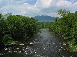
Sugar River in Claremont NH with Mount Ascutney in Vermont in the background |
||
| Data | ||
| Water code | US : 871338 | |
| location | New Hampshire (USA) | |
| River system | Connecticut River | |
| Drain over | Connecticut River → Atlantic Ocean | |
| origin |
Lake Sunapee 43 ° 23 '9 " N , 72 ° 4' 52" W. |
|
| Source height | 333 m | |
| muzzle |
Connecticut River Coordinates: 43 ° 24 ′ 7 " N , 72 ° 23 ′ 58" W 43 ° 24 ′ 7 " N , 72 ° 23 ′ 58" W. |
|
| Mouth height | 88 m | |
| Height difference | 245 m | |
| Bottom slope | 5.7 ‰ | |
| length | 43 km | |
| Catchment area | 704 km² | |
| Discharge at the West Claremont NH ( ⊙ ) A Eo gauge : 569 km²
|
MQ 1929/2012 Mq 1929/2012 |
12 m³ / s 21.1 l / (s km²) |
| Left tributaries | South Branch Sugar River | |
| Right tributaries | North Branch Sugar River | |
| Small towns | Newport , Claremont | |
| Communities | Sunapee | |
The Sugar River is a left tributary of the Connecticut River in the US state of New Hampshire .
The Sugar River forms the drain of the dammed Lake Sunapee . It flows through Sunapee , Newport and Claremont in a westerly direction , before flowing into the Connecticut River opposite Ascutney . The Sugar River has a length of 43 km and drains an area of 704 km². The South Branch Sugar River flows into the Sugar River in Newport, the North Branch Sugar River a little further downstream between Newport and North Newport.
Mills used to take advantage of the slope and hydropower of the Sugar River. There are several hydropower plants on the river.
Hydropower plants
Hydroelectric power plants in the downstream direction:
| Surname | Power in MW |
Number of turbines |
location | operator |
|---|---|---|---|---|
| Lower Village | 1.2 | 2 | ( ⊙ ) | Marlborough Hydro |
| Sweetwater | 0.9 | ( ⊙ ) | Sweetwater Hydro |
