Suldenferner
| Suldenferner | ||
|---|---|---|
|
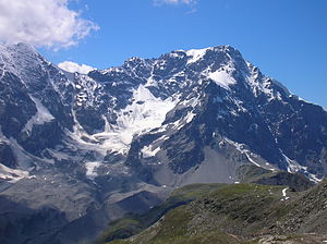
Suldenferner from the east (2008) |
||
| location | South Tyrol (Italy) | |
| Mountains | Ortler Alps | |
| Type | Valley glacier | |
| length | 4.2 km (1980) | |
| surface | 5.7 km² (2006) | |
| Exposure | Northeast | |
| Altitude range | 3900 m - 2410 m (1995) | |
| Coordinates | 46 ° 29 '24 " N , 10 ° 33' 36" E | |
|
|
||
| drainage | Suldenbach → Etsch | |
The Suldenferner ( Italian Vedretta di Solda ) is with an area of 5.7 km² after the Übeltalferner the second largest glacier in South Tyrol and after the Forni glacier also the second largest glacier in the Ortler Alps . It is located on the east side of Ortler ( 3905 m ), Monte Zebrù ( 3735 m ) and Königspitze ( 3851 m ), the highest peaks in the Ortler Alps, and is protected in the Stelvio National Park . Characteristic of the glacier, especially in the Zehr area, is the extremely heavy cover of debris that comes from the steep eastern flanks of the Ortler, Zebrù and Königsspitze , made up of Mesocian dolomite . This ablation- inhibiting debris cover causes the glacier to reach comparatively far down, namely below 2500 m. The glacier has a comparatively small nutrient area , a considerable part of the accumulation occurs through avalanches .
To the east of the glacier there are two refuge huts : on the one hand the Schaubachhütte above the end of the tongue on the opposite slope, on the other hand the Hintergrathütte at the foot of the Hintergrat, the east-south-east ridge of the Ortler.
Position and shape
The glacier is made up of four sub-streams: the western and largest sub-stream is embedded between the rear ridge and the southern ridge of the Ortler. The tributary glacier , also known as the Payerferner , coming from the cirque between Monte Zebrù and Königspitze , joins the main stream at an altitude of around 2800 m. The next partial stream coming down from the Königspitze is also called the Königswandferner . The southern tributary comes from the ridge between Kreilspitze ( 3391 m ), Schrötterhorn ( 3386 m ) and Suldenspitze ( 3387 m ). It is divided into two parts by the ridge that extends north from the Schrötterhorn, the orographically left part flows into the main stream coming from the northwest at an altitude of about 2600 m. The adjoining tongue of the glacier turns in a northeastern direction.
Historical development
For the Suldenferner an advance during the second early medieval high altitude phase of the alpine glaciers is documented. Using the radiocarbon method, it was possible to prove that the glacier had passed over a larch around the year 800 AD . This was located at the upper edge of the Legerwand, a striking steep step on the east side of the Suldental, below today's middle station of the cable car to the Schaubachhütte.
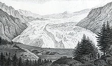
Several modern advances in the 19th and 20th centuries are also documented. The maximum advance occurred at the beginning of the 19th century. From 1815 to 1819 the glacier advanced by almost two kilometers, in the period between spring 1817 and spring 1818 alone it was 1200 meters. In 1818, advance speeds of up to 2 meters per day were measured - such surge-like advances are otherwise only known from the Vernagtferner in the Eastern Alps . This meant that the Gampenhöfe, one of the main settlement areas of today's Innersulden , had to be evacuated. The Suldenferner finally came to a stop about 300 meters from the Gampenhöfen, about at the height of the valley station of today's cable car. The glacier area during the advance is estimated at 9.56 km².
In the period that followed, there were further advances, with the highs in 1858, 1903 and 1927 no longer reaching the levels of 1819. During his last advance in 1987, the area of the glacier increased again to 6.47 m². Since then, the glacier has been melting back. The glacier inventory of 1997 recorded 5.8 km² for the Suldenferner, in 2006 it was 5.7 km². Determining the outlines of the glacier and thus the area is difficult in the Zehr area because of the heavy debris cover.
Web links
Individual evidence
- ↑ a b WGMS: Fluctuations of Glaciers Database. World Glacier Monitoring Service, Zurich 2012 ( DOI: 10.5904 / wgms-fog-2012-11 ), accessed on February 7, 2013
- ↑ a b Christoph Knoll, Hanns Kerschner: A glacier inventory for South Tyrol, Italy, based on airborne laser-scanner data. In: Annals of Glaciology. Volume 50, 2009, pp. 46–52 ( online ; PDF; 287 kB)
- ↑ a b c d e J. Stötter, S. Fuchs, M. Keiler, A. Zischg: Oberes Suldental. A high mountain region under the sign of climate change. In: E. Steinicke (Ed.): Geographical excursion guide Europaregion Tirol, South Tyrol, Trentino: Special excursions in South Tyrol. Geographie Innsbruck, pp. 244–253, Innsbruck 2003, ISBN 3-901182-35-7 ( online ; PDF; 2.4 MB)
- ↑ Herbert Louis, Klaus Fischer: General Geomorphology: Text part and separate picture part. 4th edition, Verlag de Gruyter, p. 116, Berlin 1979, ISBN 3-11-007103-7 ( Google books )
- ↑ Sebastian Finsterwalder , Max Lagally: The new measurement of the Suldenferner 1906 and its changes over the decades. In: Journal of Glacier Science. Volume 7, pp. 145–182, 1913 ( online ; PDF; 3.8 MB)
- ↑ K. Nicolussi, G. Patzelt: Investigations on the Holocene glacier development of Pasterze and Gepatschferner (Eastern Alps). In: Journal of Glacier Science and Glacial Geology. Volume 36, p. 78f, 2000 ( online ; PDF; 10.3 MB)


