Sulzbach on the Danube
|
Sulzbach on the Danube
Donaustauf market
Coordinates: 49 ° 1 ′ 43 ″ N , 12 ° 14 ′ 18 ″ E
|
|
|---|---|
| Height : | 332 m |
| Residents : | 700 |
| Incorporation : | May 1, 1978 |
| Postal code : | 93093 |
| Area code : | 09403 |
|
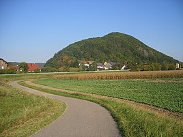
Sulzbach at the foot of the Scheuchenberg
|
|
Sulzbach an der Donau is a district of the Donaustauf market . It is located between the Scheuchenberg , the Dachsberg and the Danube , approx. 15 km from Regensburg and 2 km from Donaustauf. The Walhalla is only about a kilometer away. The Otterbach , which flows through the village, flows into the Danube near Sulzbach .
history
Grave finds in the area of Sulzbach an der Donau suggest that there was already a settlement in the 7th century AD. The first confirmed confirmation of the location comes in 914: King Conrad I donates the forest near Sulzbach to the Regensburg monastery of Sankt Emmeram . A first written mention in the year 777, mistakenly assumed for a long time, cannot be proven. Nevertheless, the folk altar of the church is engraved with "777-1977".
On a landscape painting by Albrecht Altdorfer from 1522, the Sulzbacher Kirche St. Martin with the Scheuchenberg is shown. This is the first pictorial representation of the place. This fortified church from the Middle Ages is equipped with loopholes. The church is an early Gothic hall building with a hipped gable roof and shingled roof turret with onion dome, which was later changed to Baroque style. In the 80s, the cemetery that was once around this church was closed and moved to the outskirts of Sulzbach.
In 1903 the route of the Walhalla Railway was extended to Wörth an der Donau and thus passed Sulzbach. The place received a train station, which was not only used for passenger traffic, but was also a timber handling point. For the removal of the river spate mined from around 1916 in the Sulzbacher Revier , a grinding and loading facility was built in 1928 near the train station. The fluorspar mining, which reached a peak in 1927 with over 11,000 t, was stopped again in 1991 due to extensive depletion of the deposits.
On May 1, 1978, the previously independent municipality Sulzbach was on the Danube in the market Donaustauf incorporated .
coat of arms
Since Sulzbach does not have its own coat of arms, z. B. the sports club the colors blue and red in its coat of arms. This is due to the holdings of the Princely House of Thurn and Taxis on the outskirts. The princely colors were therefore partially adopted.
Legal status
Today Sulzbach is only one district. The former independence is still reflected in club names such as the Donaustauf-Sulzbach Warrior and Reservist Association or the Donaustauf-Sulzbach CSU.
Web links
Website of the Donaustauf market
Individual evidence
- ^ Federal Statistical Office (ed.): Historical municipality directory for the Federal Republic of Germany. Name, border and key number changes in municipalities, counties and administrative districts from May 27, 1970 to December 31, 1982 . W. Kohlhammer, Stuttgart / Mainz 1983, ISBN 3-17-003263-1 , p. 658 .

