Sulzberger Ice Shelf
| Sulzberger Ice Shelf | ||
|---|---|---|
|
Environment map |
||
| Waters | Sulzberger Bay | |
| Land mass | Marie Byrd Land , West Antarctica | |
| Geographical location | 77 ° 0 ′ S , 148 ° 30 ′ W | |
|
|
||
| width | 80 km | |
| Islands | Marshall Archipelago | |
|
Topographic map sheet 1: 250,000 |
||
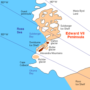
The Sulzberger Ice Shelf is a 140 km long ice shelf and 80 km wide ice shelf at the Saunders Coast of the West Antarctic Marie Byrd lands . It lies between the Edward VII Peninsula and that of the Guest Peninsula . The ten islands of the Marshall Archipelago are embedded in the Sulzberger Ice Shelf .
Participants in the first Antarctic expedition (1928–1930) by the US polar explorer Richard Evelyn Byrd discovered it and made a rough map. Byrd named the bay bounded by both peninsulas, which is filled by the ice shelf, after the newspaper editor Arthur Hays Sulzberger (1891–1968) as Sulzberger Bay . The Advisory Committee on Antarctic Names extended the naming to the ice shelf in 1966.
Web links
- Sulzberger Ice Shelf in the Geographic Names Information System of the United States Geological Survey
- Sulzberger Ice Shelf on geographic.org


