Suna (Lake Onega)
|
Suna Суна, Suunujoki |
||
|
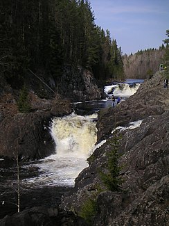
Kiwatsch waterfall |
||
| Data | ||
| Water code | RU : 01040100212102000014812 | |
| location | Republic of Karelia ( Russia ) | |
| River system | Neva | |
| Drain over | Swir → Neva → Baltic Sea | |
| origin | See Kiwijarwi 63 ° 28 '0 " N , 31 ° 54' 38" O |
|
| Source height | 364 m | |
| muzzle |
Onega Coordinates: 62 ° 6 ′ 28 " N , 34 ° 16 ′ 26" E 62 ° 6 ′ 28 " N , 34 ° 16 ′ 26" E |
|
| Mouth height | 33 m | |
| Height difference | 331 m | |
| Bottom slope | 1.2 ‰ | |
| length | 280 km | |
| Catchment area | 7670 km² | |
| Outflow location: 30 km above the mouth |
MQ |
66 m³ / s |
| Left tributaries | Semcha | |
| Medium-sized cities | Kondopoga | |
| Small towns | Porossosero | |
| River discharge, Kivach waterfall | ||
|
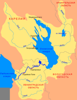
Course of the Suna (Суна) in the catchment area of the Swir |
||
The Suna ( Russian Суна ; Finnish Suunujoki ) is a river in the Republic of Karelia in northwestern Russia .
The Suna has a length of 280 km and a catchment area of 7670 km². The river has its origin in Lake Kiwijarwi and flows south past the small town of Porossosero to Lake Onega . After taking in its left tributary Semcha , much of its water has been diverted since 1936 to power the turbines of two hydropower plants. The 10.7 m high Kiwatsch waterfall is located in the lower reaches below the discharge, about 27 km before the mouth . The actual Suna flows south of Kondopoga into Lake Onega, while the majority of the water flows through the Sandal Reservoir and reaches Lake Onega at the Kondopoga hydropower plant.
At least in the past rafting was carried out on the Suna .

