Sunda Islands

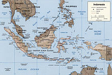
The Sunda Islands ( Sunda Archipelago) are a large group of islands in Southeast Asia between Australia and the Malay Peninsula with four very large and thousands of small islands.
geography
The Sunda Islands are part of the Malay Archipelago , which in the Ice Age - when the water level was about 100 meters lower - formed partially connected mountain ranges and a land bridge to the rear of India , the Sundaland .
The Sunda Islands are divided into the very different Large and Small Sunda Islands in an east-west direction . The Great Sunda Islands consist of Sumatra in the west, opposite the Malay Peninsula, the south-east adjoining Java , the Indonesian main island, the third largest island in the world Borneo ( Kalimantan ) in the north and Sulawesi (formerly Celebes ) in the east.
The Lesser Sunda Islands join the Greater Sunda Islands east of Java. Its main islands are Bali , Lombok , Sumbawa , Flores and Timor . In between there are numerous other small islands.
All large and most of the smaller Sunda Islands are each surrounded by a ring of even smaller to very small islands. Sumatra, Java and the Lesser Sunda Islands together form the Sunda Arc .
Politically, most of the Sunda Islands belong to Indonesia . The north of Borneo largely belongs to Malaysia , a small part forms the state of Brunei . Half of Timor forms the independent state of East Timor , which also includes two small islands.
Between the islands there are the following seas, up to 600 km wide, in a ring around Borneo and Sulawesi: Northwest of Borneo the South China Sea , south the Java Sea , east the Celebes Sea . To the east of Sulawesi are the Molucca Sea and the Banda Sea . Other seas in the region are the Floressee , the Sawuee and, to the south, the Timor Sea .
fauna and Flora
The Wallace Line , which marks the transition from the Asian flora and fauna to the Australian one , runs right through the Sunda Islands . The waters of the eastern Sunda Islands belong to the Coral Triangle , one of the most biodiverse regions of all.
history
The region was marked early on by trade with India and China. Hinduism , Buddhism and Islam spread along the trade routes. Several empires such as Srivijaya and Majapahit emerged. In the early 16th century, the Portuguese were the first Europeans to reach the region, setting up their own trading posts and conquering cities. Spaniards, English and Dutch followed. Most of the Sunda Islands became part of the Dutch East Indies , what is now the Malaysian territories and Brunei became British and the Portuguese were able to maintain the Portuguese Timor colony until 1975 . Therefore, especially in the eastern part of the islands, larger parts of the population are Christian.
During the Pacific War , the Sunda Islands were occupied by the Japanese until 1945 . After the war, decolonization began.
See also
Coordinates: 2 ° 0 ′ S , 110 ° 0 ′ E
