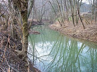
Sunday Creek (Hocking River)
| Sunday Creek | ||
|
Sunday Creek near Glouster, Ohio |
||
| Data | ||
| Water code | US : 1077000 | |
| location | southeastern state of Ohio USA | |
| River system | Mississippi River | |
| Drain over | Hocking River → Ohio River → Mississippi River → Gulf of Mexico | |
| origin | Approximately 5 miles north of Corning in Perry County, OH 39 ° 40 ′ 28 " N , 82 ° 5 ′ 38" W |
|
| Source height | 312 m | |
| muzzle | Hocking River, 1 km southeast of Chauncy in Athens County, OH Coordinates: 39 ° 23 '30 " N , 82 ° 7' 23" W 39 ° 23 '30 " N , 82 ° 7' 23" W |
|
| Mouth height | 194 m | |
| Height difference | 118 m | |
| Bottom slope | 2.7 ‰ | |
| length | 43.8 km | |
| Catchment area | 360 km² | |
| Left tributaries | East Branch Sunday Creek | |
| Right tributaries | West Branch Sunday Creek | |
The Sunday Creek is a 43.8 km long left tributary of the Hocking River in the southeastern US state of Ohio . The outflow is via the Hocking River, Ohio River and Mississippi River into the Gulf of Mexico . According to legend, European immigrants named the river after the day of the week they discovered it. The Sunday Creek is part of the river system of the Mississippi River and drains an area of 360 square kilometers. The river has its source around 8 km north of the town of Corning in Perry County , flows generally south into northern Athens County and flows into the Hocking River at Chauncy. The main tributaries are the 25 km long East Branch Sunday Creek and the 22.5 km long West Branch Sunday Creek . The East Fork Sunday Creek was dammed by the US Army Corps of Engineers to Burr Oak Lake in 1950 and the Burr Oak State Park established.
The intensive coal mining in the catchment area of the Sunday River led to irreparable environmental damage. The first coal mines were built around 1860 and closed in 1991. Open pit coal mining began after the Second World War and ended in the 1970s. The Ohio Environmental Protection Agency (EPA) held coal mining in the Monday Creek catchment area primarily responsible for polluting the river as it released high levels of phosphorus . The agency found that Sunday Creek was irretrievably altered to the extent that no significant aquatic life could exist due to significant pollution from acid mine water . The Sunday Creek Watershed Group was founded in 2004 to sustainably improve the water quality in Sunday Creek.
Individual evidence
- ↑ a b Google Earth altitude for GNIS coordinates, accessed on July 25, 2010.
- ^ A b Sunday Creek (Hocking River) in the Geographic Names Information System of the United States Geological Survey , accessed July 25, 2010
- ↑ Sunday Creek Watershed ( Memento of the original from September 29, 2011 in the Internet Archive ) Info: The archive link was automatically inserted and not yet checked. Please check the original and archive link according to the instructions and then remove this notice. , accessed on July 25, 2010
- ↑ Environmental Protection Agency - Sunday Creek ( page no longer available , search in web archives ) Info: The link was automatically marked as defective. Please check the link according to the instructions and then remove this notice. , accessed on July 25, 2010
- ^ Sunday Creek Watershed Group , accessed July 25, 2010
