Świna

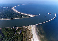
The Świna [ɕfiːna] (German Swine ) is an arm of the Baltic Sea that connects the Stettiner Haff and the Baltic Sea between the islands of Usedom and Wolin (German: Wollin) . It is located in Poland and, along with the Peenestrom and the Dziwna (Eng. Dievenow), is one of a total of three such sea gates . At its exit to the Baltic Sea lies the port city named after it Świnoujście (German: Swinoujscie). In principle, the Świna has a current directed towards the sea, as the water of the Oder mainly takes this route from the Stettiner Haff to the Baltic Sea. If the north winds persist, however, the current can reverse and push Baltic Sea water through the Świna into the lagoon. Since the water penetrating from the Baltic Sea is heavily contaminated with sediment, a very rare rear delta (also: regressive delta ) has developed towards the lagoon.
history
From 1729 to 1745 the Swine was deepened to make it passable for merchant ships to and from Szczecin . The aim of the Prussian administration was to build an alternative route to the Swedish-controlled Peene River . Further financial support was given to boatmen and merchants for the costly measure. These were linked to the requirement to use the Swine to pass through. Even so, most of the Pomeranian ships kept their traditional route across the Peene River. Despite the customs duties to be paid to the Swedes, they preferred to be able to do additional business in Wolgast . The Swedish Pomeranian administration , on the other hand, had forbidden its subjects to pass through Swine. Only after the expansion of the Świnoujście port in 1746 was there a revival in the timber trade via the Świna.
At the beginning of the 1880s, the Swine was deepened again for shipping and straightened by the Mellinfahrt (today Kanał Mieliński). Through the Kaiserfahrt , completed in 1880 , today Kanał Piastowski , the south-east of Usedom with the places Caseburg (today Karsibór) , Woitzig and Lohberg (no longer available today) became a separate island. Today the island of Karsibór is connected to the island of Wolin with a modern bridge over the Stara Świna (German: Old Swine) instead of the earlier single-lane bridge.
Traffic significance
As early as 1230, Duke Barnim I of Pomerania had a ferry connection established across the Świna. The villages of Ost- and Westswine were given the right and duty to operate the ferry in exchange for a lease payment. From 1874 steam ships were used for ferry traffic. Since 1900, a consisted ferry across the railway line Wollin -Ostswine. The connection between the island of Usedom and the island of Wolin is now ensured by two ferry crossings that can be used by pedestrians and cyclists, but also by motor vehicles. The line from the port on the west bank of the Świna to the Warszów district is mainly used by cars and is officially reserved for the residents of Świnoujście, which is now on both sides of the Świna. The second line, which runs immediately north of the confluence with the Kaiserfahrt, has larger ferries and is used more for freight traffic to and from the Polish part of the island of Usedom and by foreign cars. Crossing the Świna by rail is just as impossible today as it is to continue heavy goods traffic over the border crossings on Usedom to Germany.
However, an agreement was signed in spring 2017 that provides for a tunnel to be built under the Swine with completion in 2022. The financing of the Swinetunnel (planned 912,000,000 PLN) is supported to 85% by the EU.
Web links
Individual evidence
- ↑ Hans Branig : History of Pomerania. Part II. From 1648 to the end of the 18th century . Böhlau Verlag, Cologne / Weimar / Vienna 2000, ISBN 3-412-09796-9 , pp. 121–122.
- ↑ Branig: History of Pomerania Part II , p. 158.
- ↑ coastal and bathrooms Card: Pomerania. Pharus-Plan GmbH Berlin. M 1: 120,000
- ↑ Świnoujście: History of the City (as of August 9, 2014)
- ↑ Ferries from Swinoujscie to Ostswine ( Memento from August 10, 2014 in the Internet Archive )
- ↑ https://tantower.wordpress.com/2017/06/07/in-deutschland-bekam-es-kaum-jemand-mit-die-swine-wird-untertunnelt/
- ↑ https://www.cupt.gov.pl/?id=2501
Coordinates: 53 ° 54 ′ 11 " N , 14 ° 15 ′ 25" E


