
Synky
| Synky | |||
| Синьки | |||

|
|
||
| Basic data | |||
|---|---|---|---|
| Oblast : | Kirovohrad Oblast | ||
| Rajon : | Blahowishshenske district | ||
| Height : | 172 m | ||
| Area : | Information is missing | ||
| Residents : | 1,292 (2001) | ||
| Postcodes : | 26411 | ||
| Area code : | +380 5259 | ||
| Geographic location : | 48 ° 28 ' N , 30 ° 16' E | ||
| KOATUU : | 3525589901 | ||
| Administrative structure : | 1 village | ||
| Address: | вул. Леніна, буд. 17 26411 с. Синьки |
||
| Website : | City council website | ||
| Statistical information | |||
|
|||


Synky ( Ukrainian Синьки ; Russian Синьки Sinki ) is a village in the west of the Ukrainian Oblast Kirowohrad with about 1,300 inhabitants (2001).

The village emerged in the second half of the 18th century when several farms grew together.
geography
Synky is the only village of the district council of the same name in the north of Blahowishshenske Rajon .
The village lies on an unnamed, km long 14, left tributary of the Synyzja ( Синиця ), a 79 km long tributary of the Southern Bug , 22 km north of Rajonzentrum Blahowischtschenske and 170 km west of the Oblastzentrum Kropywnyzkyj . To the west of the village, the M 05 E 95 road runs in a north-south direction .

Village church

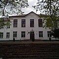
town hall
school

Service area on the M 05


Web links
Commons : Synky - collection of images, videos and audio files
Individual evidence
- ↑ Local website on the official website of the Verkhovna Rada ; accessed on May 15, 2018 (Ukrainian)
- ↑ history Synky in the history of the towns and villages of the Ukrainian SSR ; accessed on May 15, 2018 (Ukrainian)