Syrjanka (Kolyma)
|
Syrjanka Zyranka |
||
|
|
||
| Data | ||
| Water code | RU : 19010100412119000036920 | |
| location | Sakha Republic ( Russia ) | |
| River system | Kolyma | |
| Drain over | Kolyma → Arctic Ocean | |
| source | in the Garmytschan mountain range ( Moma mountains ) 65 ° 12 ′ 19 ″ N , 147 ° 49 ′ 10 ″ E |
|
| muzzle | at Syrjanka in the Kolyma coordinates: 65 ° 49 ′ 29 " N , 150 ° 46 ′ 38" E 65 ° 49 ′ 29 " N , 150 ° 46 ′ 38" E
|
|
| length | 299 km | |
| Catchment area | 7310 km² | |
| Left tributaries | Sibik | |
| Communities | Syrjanka | |
|
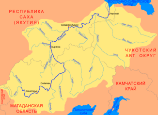
Course of the Syrjanka (Зырянка) in the catchment area of the Kolyma |
||
The Syrjanka ( Russian Зырянка ) is a left tributary of the Kolyma in the north of Eastern Siberia .
The Zyryanka rises in the mountain range Garmytschan (Гармычан) in the south of Momagebirges . It cuts through the mountain ranges of the Moma Mountains running in NW- SE direction and reaches the Kolyma Lowland below the mouth of the Sibik (Сибик) . After another 106 km the Syrjanka meets the Kolyma at the urban-type settlement of the same name . The Syrjanka has a length of 299 km. Its catchment area covers 7310 km². The Syrjanka is ice-covered between October and the end of May.
