
Taipa mangonui
| Taipa mangonui | ||
| Geographical location | ||
|
||
| Coordinates | 35 ° 0 ′ S , 173 ° 30 ′ E | |
| Region ISO | NZ-NTL | |
| Country |
|
|
| region | Northland | |
| District | Far North District | |
| Ward | Te Hiku Ward | |
| Residents | 1 662 (2013) | |
| height | 10 m | |
| Post Code | 0420 | |
| Telephone code | +64 (0) 9 | |

Taipa-Mangonui , or Taipa Bay - Mangonui , is the name of a chain of small coastal resorts in the Far North District of Northland on the North Island of New Zealand .
geography
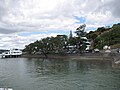
The group of coastal resorts includes, from west to east, Taipa , Cable Bay , Cooper's Beach, and Mangonui . They are located around 25 km northeast of Kaitaia and around 47 km northwest of Kerikeri at the southeast end of Doubtless Bay . The places extend on the coast over a length of about 6 km, with Mangonui extending into Mangonui Harbor , on the west side of which the place is located.
population
In the 2013 census, the coastal strip had 1,662 inhabitants, 5.9% more than in the 2006 census.
Education
Taipa , located to the west, has the Taipa Area School , a Composit School with grades 1 to 15. In 2014, 287 students attended the school. On the other hand has the easterly Mangonui with the Mangonui School a primary school with grades 1 to 8. In 2017, visited 158 pupils to the school.
Photo gallery
Coast in Mangonui

Mangonui

Coast in Mangonui

Dense residential development around Mangonui


Individual evidence
- ↑ a b 2013 Census QuickStats about a place : Taipa Bay - Mangonui . Statistics New Zealand , accessed September 16, 2014 .
- ↑ Topo250 maps . Land Information New Zealand , accessed October 15, 2017 .
- ^ Taipa Area School . Education Review Office , accessed October 15, 2017 .
- ↑ Mangonu School . Education Review Office , accessed October 15, 2017 .