Talas (river)
|
Talas Талас |
||
| Data | ||
| location |
Talas ( Kyrgyzstan ), Shambyl ( Kazakhstan ) |
|
| River system | Talas | |
| Confluence of |
Karakol and Uchkoschoi 42 ° 29 ′ 25 ″ N , 72 ° 34 ′ 1 ″ E |
|
| Source height | 1508 m | |
| Infiltration | in the Mujunkum desert coordinates: 43 ° 55 ′ 0 ″ N , 70 ° 30 ′ 0 ″ E 43 ° 55 ′ 0 ″ N , 70 ° 30 ′ 0 ″ E
|
|
| length | 661 km | |
| Catchment area | 52,700 km² | |
| Outflow location: 555 km above the mouth |
MQ |
15.7 m³ / s |
| Outflow location: 444 km above the mouth |
MQ |
27.4 m³ / s |
| Right tributaries | Beschtasch , Karagajyng , Kümüschtak | |
| Reservoirs flowed through | Kirov dam | |
| Big cities | Taras | |
| Medium-sized cities | Talas | |
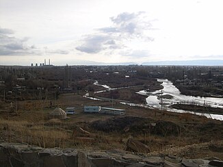
The 661 km long Talas River ( Russian and Kazakh Талас ) is a river in the north of Kyrgyzstan and in the southeast of Kazakhstan ( Central Asia ).
It arises in the Talas area in the Kyrgyz mountains through the confluence of the Karakol and Uchkoschoi rivers near Chatbasar . In the further course of the river many small rivers and streams flow into it. It flows through the high mountains initially towards the west and flows through the city of Talas . The river flows through the Kirov reservoir . Then he leaves the mountains towards the northwest, crosses the border with Kazakhstan and there reaches the city of Taras , formerly called Jambul . The river's water is used intensively for irrigation in agriculture , so that the Talas only dries up about 100 to 200 km below Taras in the Mujunkum desert, depending on the amount of water carried .
The catchment area of the Talas covers around 52,700 km². The Talas Valley is a traditional settlement area of the Kyrgyzstan Germans .


