Morrow Point Dam
| Morrow Point Dam | ||
|---|---|---|
| location | ||
|
|
||
| Coordinates | 38 ° 27 '7 " N , 107 ° 32' 17" W | |
| country |
|
|
| place | Montrose County , Colorado | |
| Waters | Gunnison River | |
| Height upstream | 2182 m | |
| power plant | ||
| owner | United States Bureau of Reclamation (USBR) | |
| operator | USBR | |
| construction time | 1963 to 1968 | |
| Start of operation | 1970 | |
| technology | ||
| Bottleneck performance | 173.3 megawatts | |
| Average height of fall |
120 m | |
| Standard work capacity | 343.45 million kWh / year | |
| Turbines | Francis turbines : 2 × 86.6 MW | |
| Others | ||
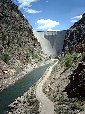
The dam Morrow Point ( English Morrow Point Dam ) is a dam with hydroelectric power station in Montrose County , State of Colorado , USA . It dams the Gunnison River to a reservoir ( English Morrow Point Reservoir ). The Blue Mesa Dam is located approximately 19 km (12 miles ) upstream and the Crystal Dam is approximately 9.5 km (6 miles) downstream of the Morrow Point Dam. The dam and the reservoir are in the Curecanti National Recreation Area .
In addition to generating electricity, the dam is also used for flood protection . Construction of the dam began in 1963. It was completed in 1968. The dam is owned by the United States Bureau of Reclamation (USBR) and is also operated by the USBR.
Barrier structure
The shut-off is a double-curved arch dam of concrete with a height of 142.5 m (468 ft ) above the foundation bed . The top of the wall is at an altitude of 2184 m (7165 ft) above sea level . The length of the top of the wall is 220.5 m (724 ft). The thickness of the dam is 15.8 m (52 ft) at the base and 3.65 m (12 ft) at the top. The volume of the structure is 279,200 m³ (365,180 cubic yards ).
The flood relief consists of four openings at the top of the wall. A maximum of 1161 m³ / s (41,000 cft / s) can be discharged via the flood discharge, and a combined maximum of 184 m³ / s (6500 cft / s) via the turbine inlet and the bottom outlet .
Reservoir
At the normal storage target of 2182 m (7160 ft), the reservoir extends over an area of around 3.31 km² (817 acres ) and holds 145 million m³ (117,190 acre-feet ) of water.
power plant
The power plant went into operation in 1970. The installed capacity is 173.3 MW ; it was originally 120 MW. From 1992 to 1993 an increase in performance was carried out; the power plant's two Francis turbines each have a maximum output of 86.667 MW (previously 60 MW). The drop height is 120 m (396 ft). The power plant serves to cover peak loads .
The average annual production is around 269 (or 343.45) million kWh .
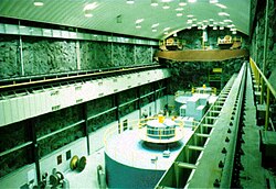
The machine hall of the power plant is located in a cavern on the left side of the river. The cavern is 70 m (231 ft) in length and 17 m (57 ft) in width. Their maximum height is 41 m (134 ft).
See also
Web links
Individual evidence
- ↑ a b c d Morrow Point Dam. United States Bureau of Reclamation (USBR), accessed November 21, 2018 .
- ↑ a b c Aspinall Unit. USBR, accessed November 21, 2018 .
- ^ Aspinall Unit Operations Final Environmental Impact Statement. (PDF) USBR, January 1, 2012, pp. 1–4 (32) , accessed on November 21, 2018 (English).
- ↑ a b Morrow Point Powerplant. USBR, accessed November 21, 2018 .


