Tavros
|
Tavros municipality Δημοτική Ενότητα Ταύρου (Ταύρος) |
||
|---|---|---|
|
|
||
| Basic data | ||
| State : |
|
|
| Region : |
Attica
|
|
| Regional District : | Athens South | |
| Municipality : | Moschato Tavros | |
| Geographic coordinates : | 37 ° 58 ′ N , 23 ° 42 ′ E | |
| Height above d. M .: | 15 m (average) |
|
| Area : | 2.12 km² | |
| Residents : | 14,972 (2011) | |
| Population density : | 7,062.3 inhabitants / km² | |
| Code No .: | 480602 | |
| Structure: |
1 municipality |
|
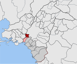
| Located in the municipality of Moschato-Tavros and in the Athens-South regional unit | ||
Tavros ( Greek Ταύρος , bull ') is a suburb in the southwest of Athens . Athens is about 4 km from the center and 3 km from the outskirts of Tavros. It is 6 km to downtown Piraeus .
In the past Tavros consisted almost entirely of farmland and farms, until the expansion of Athens and extensive urbanization of the area at the beginning of the 20th century almost completely displaced agriculture. Nowadays Tavros is mainly a residential area, with the industrial area in the north of the city. The largest street in Tavros is Piraeus Street.
The municipality, which was independent from 1943 to 2010, was merged with the neighboring Moschato to form the municipality of Moschato-Tavros through the 2010 administrative reform .
Individual evidence
- ↑ Results of the 2011 census, Greek Statistical Office (ΕΛ.ΣΤΑΤ) ( Memento from June 27, 2015 in the Internet Archive ) (Excel document, 2.6 MB)

