Tepeaca
| Tepeaca | ||
|---|---|---|
|
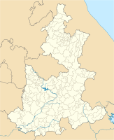
Coordinates: 18 ° 58 ′ N , 97 ° 54 ′ W Tepeaca on the map of Puebla
|
||
| Basic data | ||
| Country | Mexico | |
| State | Puebla | |
| Municipio | Tepeaca | |
| City foundation | September 4, 1520 | |
| Residents | 27,449 (2010) | |
| Detailed data | ||
| height | 2240 m | |
| Post Code | 75200 | |
| prefix | (+52) 223 | |
| Time zone | UTC −6 | |
| City Presidency | David Edgardo Huerta Ruiz | |
| Website | ||
Tepeaca is a city in the central part of the Mexican state of Puebla , about 34 km east of the capital Puebla in a valley basin at an altitude of 2240 m. In pre-Hispanic times the name of the city was Tepeyacac (formed from the words tepētl , "mountain" and yacatl , "nose, tip" plus locative suffix) and can be translated as "on the mountain promontory", which corresponds to the location of the place at the foothills of a mountain range .
Today Tepeaca has approx. 27,000 inhabitants and is the seat of the Municipio Tepeaca .
history
The pre-Hispanic history of Tepeyaca only becomes tangible as soon as the region comes under the influence of Tenochtitlan . In the middle of the 15th century, the Aztecs began forays towards Oaxaca and the coast of the Gulf of Mexico to expand their dominion south. Since the Tepeyacac neighboring city of Cuauhtinchan belonged first to the sphere of influence of Tlatelolco and then to Tenochtitlan through marriage alliance and military presence , Tepeyacac was the next target, which was conquered around 1465. In the period that followed, with Tepeyacac as the administrative center, a broad tributary province emerged that occupied roughly the middle of the modern state of Puebla.
In the course of the Spanish conquest , when the small Spanish army that remained after the Noche Triste stayed in Tlaxcala , one of the first Spanish cities was founded in Tepeyacac in September 1520 to secure the route to the coast that had existed at least since the Aztec expansion, with the descriptive name "Villa de Segura de la Frontera" (City of Border Security)
In 1543, Segura de la Frontera was relocated to the foot of the hill as part of the Franciscan policy of consolidating settlements and moving them from easily defended hills to the plain. A large monastery dedicated to St. Francis of Assisi was built on the new site . The colonial administrative unit Alcaldía Mayor of Tepeaca comprised only the northeastern part of the pre-Hispanic tribute province.
Individual evidence
- ^ Peter Gerhard: Geografía histórica de la Nueva España 1519-1821. Universidad Nacional Autónoma de México, México 1986. ISBN 968-36-0293-2

