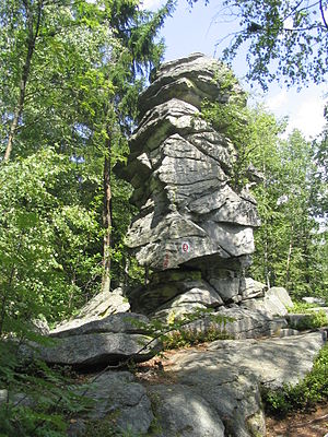
Devil's Table (Bavarian Forest)
| Devil table | ||
|---|---|---|
| height | 901 m | |
| location | Bavaria | |
| Mountains | Bavarian forest | |
| Coordinates | 48 ° 56 '1 " N , 13 ° 3' 50" E | |
|
|
||
| rock | Gneiss | |
The Teufelstisch (901 m) is a legendary rock formation near Bischofsmais in the central Bavarian Forest and a very popular hiking destination . It forms its own small ridge with considerable rocks along the ridge height.
A popular hiking trail, which however requires surefootedness, leads from Bischofsmais to the Teufelstisch, then along the rocky ridge with beautiful views over and over again to a fork in the path, after which it goes down to Habischried or Tiefenried. This hike can be easily combined with the neighboring Geißkopf .
Several routes lead to the actual devil's table. The normal route leads in difficulty II + up in a few moves. On the south side there are two more routes of difficulty IV and IV +.
Geotope
The summit ridge of the Teufelstisch is designated by the Bavarian State Office for the Environment as a valuable geotope (geotope number: 276R010).
Individual evidence
- ^ Bavarian State Office for the Environment, Geotop summit ridge of the Teufelstisch NW von Bischofsmais (accessed on October 18, 2017).

