
Goat's head
| Goat's head | ||
|---|---|---|
 Geißkopfhütte |
||
| height | 1097.4 m above sea level NHN | |
| location | Regen district , Bavaria , Europe | |
| Mountains | Bavarian forest | |
| Coordinates | 48 ° 55 '29 " N , 13 ° 2' 17" E | |
|
||
| rock | Gneiss | |
| particularities | Geißkopf tower ( AT ) | |

The Geißkopf is 1097.4 m above sea level. NHN high mountain in the Bavarian Forest .
location
The Geißkopf is located near the municipality of Bischofsmais in the Breitenau , an area that also includes Breitenauriegel , Dreitannenriegel and Einödriegel .
tourism
The mountain has been cultivated as a local recreation area and for tourism since the 1960s. In addition to hiking opportunities, there is a 1,142-meter-long chairlift opened in 1967/68 , 3 longer and 3 shorter drag lifts with 9 ski runs and a summer and winter toboggan run. In summer, mountain bikes can also be transported with the chairlift, 12 runs in the bike park are available. On the summit there is a mountain restaurant and a 23 meter high wooden observation tower, which allows a wide panoramic view of the rear Bavarian Forest. There is also a transmitting antenna for broadcasting the radio program "Our Radio Regen" on 89.3 MHz with 200 W ERP. This makes it one of the few wooden towers that now broadcast radio programs.
A few hundred meters from the summit is the Oberbreitenau , a clearing that was previously inhabited. Today the Landshut House, managed by the Bavarian Forest Association, is located there .

Observation tower
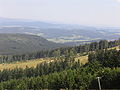
View from Geißkopf

Winter tourism on the Geißkopf

