Three fir bars
| Three fir bars | ||
|---|---|---|
|
Dreitannenriegel summit |
||
| height | 1090.2 m | |
| location | District of Deggendorf , Bavaria , Germany | |
| Mountains | Bavarian forest | |
| Coordinates | 48 ° 53 '51 " N , 13 ° 1' 20" E | |
|
|
||
| rock | Gneiss | |
The three- fir tree is a 1090.2 m above sea level. NHN high mountain in the Bavarian Forest .
The mountain rises in the ridge of the Middle Bavarian Forest high above the Lower Bavarian district town of Deggendorf and is located in the district Alberting the community Grafling . Neighboring mountains are the Breitenauriegel , the Geißkopf and the Einödriegel .
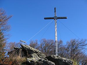
On the summit there is a large summit cross and a display board that explains the panorama over large parts of Lower Bavaria . On clear autumn days at Föhneinfluss which also are the Bavarian Alps to see.
The Dreitannenriegel can be reached on foot on several hiking trails from Grafling , Gotteszell , Habischried , Bischofsmais and Rusel . One of the steepest climbs in the front Bavarian Forest leads via hiking trail 3 from Mietraching in Deggendorf through the Sauloch up to Rohrmünz (about 45 minutes) and from there almost directly on the fall line to the summit. This section is only to be walked on with sturdy shoes, as smooth rocks have to be crossed, especially on the ascent to the summit.
The summit and a large proportion of the slope areas belong to the FFH area Deggendorfer Vorwald .
Individual evidence
- ↑ Map services of the Federal Agency for Nature Conservation ( information )
- ↑ BayernViewer
- ↑ www.bayerischer-wald.de ( page no longer available , search in web archives ) Info: The link was automatically marked as defective. Please check the link according to the instructions and then remove this notice.
- ↑ http://www.protectedplanet.net

