
The Lions
| The Lions | ||
|---|---|---|
 The Lions from Capilano Lake viewed from |
||
| height | 1654 m | |
| location | British Columbia ( Canada ) | |
| Mountains | North Shore Mountains | |
| Coordinates | 49 ° 27 '28 " N , 123 ° 11' 11" W | |
|
||
| rock | Diorite | |
| First ascent | 1889 | |

The Lions are twin peaks in the North Shore Mountains in Greater Vancouver in the Canadian province of British Columbia .
They consist of the west summit West Lion ( 1654 m height) and the east summit East Lion ( 1606 m height). Due to their proximity to the coast, they are visible from afar, for example from the suburbs of Vancouver as well as the Howe Sound Islands and the Sunshine Coast . With the named after her common Gate Bridge Lions are The Lions , a landmark of the city of Vancouver. The BC Lions of the CFL are also named after the twin peaks.
geology
The rock of the mountain consists of hornblende diorite , the oldest deep rock on the west coast of Canada. From a distance, the two peaks look like lions' heads, which is where the name for the peaks comes from.
Hiking and climbing routes
Hikers can reach the ridge between the two peaks via the Binkert Trail beginning in Lions Bay or via the Howe Sound Crest Trail . The Binkert Trail, named after Paul Binkert of the British Columbia Mountaineering Club , is one of the most popular hiking routes in the Lower Mainland . The ascent from Lions Bay takes about four hours and the difference in altitude is 1,280 m. The two peaks can only be climbed with climbing equipment and appropriate experience, whereby the eastern summit East Lion is closed to climbers due to its location in the catchment area of the drinking water supply.
First ascents
Steven Threndyle writes in his book The Greater Vancouver Book that the first ascent of the West Lion in 1889 should have been more of a coincidence. A group of hunters, led by Chief Joe Capilano of the Squamish , had followed a herd of goats and suddenly found themselves on the western summit. Henry Bell-Irving, who was part of the group, asked Capilano to have one of the young Squamish descend to the ridge and climb back to the top. The young Squamish made the descent and ascent in under 20 minutes.
Due to the high and steeply sloping granite wall on the East Lion , the east summit was believed to be impassable until 1903 John Latta and his two brothers climbed the east summit without equipment.
"The Sisters"
The indigenous Squamish gave the twin peaks the name Ch'ich'iyúy Elxwíkn , which translates as "the twin sisters". They are sacred to the Squamish because of their use as markers for peace treaties, ancestral stories, and spiritual guides. According to the legends of the Squamish the peaks of the were Sky Brothers (dt. Sky Brothers ) created after the twin sisters Squamish twins Haida had married, to end the war between Squamish and heath. The resulting family branches are said to still exist in both First Nations today. The current name is said to have been proposed around 1890 by Judge John Hamilton Gray, who is based on the couchant from heraldry .
gallery

The Lions as seen from Unnecessary Mountain - the difference in altitude between the two peaks is clear
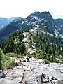
Ridge of the mountain towards the west summit
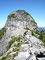
West Lion , view from the ridge (1,525 m) between the two peaks.

East Lion , view from the ridge


Web links
- The Lions . In: BC Geographical Names (English)
Individual evidence
- ^ West Lion in the Internet version of the English-language Canadian Mountain Encyclopedia
- ^ East Lion in the Internet version of the English-language Canadian Mountain Encyclopedia
- ^ Lions Gate Bridge ( English, French ) In: The Canadian Encyclopedia . Retrieved July 29, 2019.
- ^ The Greater Vancouver Book , an urban encyclopedia, Chuck Davis - Editor in Chief. Linkman Press. 1997. ISBN 978-1-896846-00-2
- ^ British Columbia Place Names. GPV and Helen B. Akrigg. Vancouver: UBC Press, 1997