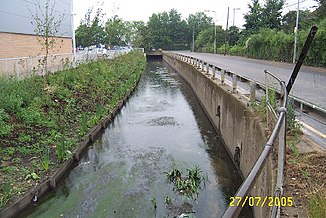
The Roxbourne
|
The Roxbourne Yeading Brook in the lower reaches |
||
|
The Roxbourne in South Ruislip |
||
| Data | ||
| location |
London Borough of Harrow , London Borough of Hillingdon , England |
|
| River system | Thames | |
| Drain over | Yeading Brook → River Crane → Thames → North Sea | |
| source | at South Harrow, 51 ° 34 ′ 9 " N , 0 ° 21 ′ 58" W. |
|
| muzzle | in Yeading Brook coordinates: 51 ° 32 '45 " N , 0 ° 24' 57" W 51 ° 32 '45 " N , 0 ° 24' 57" W.
|
|
The The Roxbourne is a watercourse in Greater London . It arises in the London Borough of Harrow in the district of South Harrow and flows in a south-westerly direction through South Ruislip . There it runs underground from a point northeast of Field End Road to a point just southwest of the subway line in the southeast of South Ruislip subway station. After its return to the surface it was given the name Yeading Brook , into whose main arm it flows south of the A40 near the RAF Northolt airfield .
