Theunissen (South Africa)
| Theunissen | ||
|---|---|---|
|
|
||
| Coordinates | 28 ° 24 '7 " S , 26 ° 42' 36" E | |
| Basic data | ||
| Country | South Africa | |
| free State | ||
| District | Lejweleputswa | |
| ISO 3166-2 | ZA-FS | |
| local community | Masilonyana | |
| height | 1422 m | |
| surface | 9.2 km² | |
| Residents | 1549 (2011) | |
| density | 169.3 Ew. / km² | |
| founding | 1907 | |
|
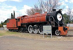
Monument locomotive in Theunissen
|
||
Theunissen is a city in the South African province of Free State (Free State). It is the seat of the Masilonyana municipality in the Lejweleputswa district .
geography
According to the census, Theunissen had 1,549 inhabitants in 2011, and the township of Masilo , located immediately south, had 21,963 inhabitants. Theunissen is located south of the Free State's gold fields . The environment is relatively flat.
history
The local commander in the Second Boer War , Helgaardt Theunissen, founded the city in 1907 at a railway junction.
In 2018, 955 miners were trapped underground for 24 hours in the “Beatrix Mine”, where gold is mined, after a power failure.
Economy and Transport
Theunissen is an agricultural center. The city has the only winery in the province. In the Beatrix mine is gold promoted. It is operated by Sibanye-Stillwater .
The place is on the R30 trunk road , which connects Theunissen with, among others, Brandfort and Bloemfontein in the south and Welkom in the north, and the R708, which leads east towards Winburg . Theunissen is on the Johannesburg – Bloemfontein railway line and is used for freight traffic. A branch line leads to Winburg.
Personalities
- Neville Lederle (1938–2019), racing car driver, born in Theunissen
Web links
- Portrait at south-africa-info.co.za (English)
Individual evidence
- ^ Theunissen , 2011 census, accessed on July 6, 2017
- ^ Masilo , 2011 Census, accessed July 6, 2017
- ↑ a b portrait at south-africa-info.co.za (English), accessed on July 7, 2017
- ↑ All 955 miners trapped in S. Africa rescued ( Memento of February 3, 2018 in the Internet Archive ) journalducameroun.com, February 2, 2018 (English)
- ^ South Africa Touring Atlas. Map Studio, Johannesburg 1988, ISBN 1-86809-089-2

