Thielenbruch (district)
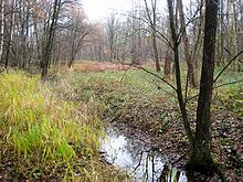
Thielenbruch is a district in the Dellbrück district on the eastern outskirts of Cologne . It consists of a housing estate, which is surrounded by partially protected landscape elements. The boundaries of the residential area, which is also sometimes referred to as the villa district, run north partly on Bergisch Gladbacher Straße and partly on Paffrather Straße, east on Thielenbrucher Allee, south on the streets in Eichenforst and Gemarkenstraße and west on Otto-Kayser -Street. The protected area east to the city limits of Bergisch Gladbach is called Thielenbruch in common parlance and on maps (see map section: 50 ° 58 '42.9 ″ N , 7 ° 5 ′ 39.5 ″ E ). It is part of the Bergische Heideterrasse .
history
Naming
The personal name Thiel is contained in the determiner Thielen . Thiel von Thurn was the owner of the Thurner Hof and since 1412 also the owner of the Thielenbruch. The basic word bruch is derived from the Old High German bruoh and the Middle High German bruoch (= bog soil, swamp) and indicates swampy terrain. In 1730, the settlement on the south-eastern edge of the Thielenbruch was mentioned as Thiel Gut in the Hebborner Hof's tax list . Between 1928 and 1935 it was named Thielenbrucher Hof .
colonization
The Thielenbruch was always a moorland through which no road ran. Only in 1842 was there an east-west connection with today's Bergisch Gladbacher Strasse. As a result of its completion, the street was a prerequisite for the possibility of later development of the adjacent properties. The first houses were built in 1901 and move into a year later.
Mining
In the mid-19th century mining was in the Thielenbruch open pit on iron operated. These were the Franconia mine and the Hohenzollern mine , of which the pings can still be seen today .
Protected areas
In 1969, which was fen Thielenbruch under conservation provided. It is divided into differently protected individual areas, such as the Thielenbruch nature reserve and Thurner Wald and other areas that are designated as nature reserves , landscape protection areas or as a protected landscape component in the landscape plan of the city of Cologne . There are official signs with the relevant inscriptions around the areas. In some places you can also find panels that provide information about nature in the Thielenbruch.
tram
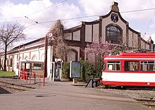
After the city of Cologne built a car shed and stop for the planned small train from Cologne to Bergisch Gladbach in 1903 , the station name Thielenbruch was chosen based on the neighboring forest. Today this is the final stop of line 3 and line 18 of the Cologne transport company . The Thielenbruch Tram Museum is located in the old tram buildings .
Individual evidence
- ^ A b Hans-Hermann Cramer, Hans Florath, Hans-Walter Lau, Manfred Richter and Klaus Werner: Thielenbruch - From the forest to the villa district, published by the Thielenbruch Citizens' Association of 1975, Cologne 1998, p. 6ff.
- ^ Andree Schulte, Bergisch Gladbach, Stadtgeschichte in Straßenennamen , Bergisch Gladbach 1995, ISBN 3-9804448-0-5 , pp. 120f.
- ↑ Ordinance on the nature reserve "Flachmoor Thielenbruch" in the city of Cologne from July 10, 1969. Official Gazette Government of Cologne 1969, page 336, corrected 1969, page 363
- ^ "Thielenbruch und Thurner Wald" nature reserve in the specialist information system of the State Office for Nature, Environment and Consumer Protection in North Rhine-Westphalia , accessed on February 23, 2017.
- ↑ Landscape plan of the city of Cologne - L 27 LSG Dellbrücker Wald, upstream open spaces and connecting green areas, accessed on December 27, 2016
Web links
Coordinates: 50 ° 58 ′ 50 ″ N , 7 ° 5 ′ 11.5 ″ E

