
Thiou (river)
| Thiou | ||
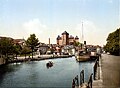
 Thiou at the Palais de l'Isle in Annecy |
||
| Data | ||
| location | France , Auvergne-Rhône-Alpes region | |
| River system | Fier | |
| Drain over | Rhone → Mediterranean | |
| source | Lac d'Annecy discharge 45 ° 53 ′ 54 ″ N , 6 ° 7 ′ 54 ″ E |
|
| muzzle | in Cran-Gevrier in the Fier coordinates: 45 ° 54 ′ 35 " N , 6 ° 5 ′ 56" E 45 ° 54 ′ 35 " N , 6 ° 5 ′ 56" E
|
|
| length | 3.5 km | |
The Thiou is a river in southeastern France that runs in the Haute-Savoie department in the Auvergne-Rhône-Alpes region . It is the natural outflow of the 27 km² large lake Lac d'Annecy and one of the shortest rivers in the country. After only 3.5 kilometers it joins the Fier .
Starting at the northwesternmost point of the lake, the Thiou is widened for the first 200 meters to a 32-meter-wide harbor basin, the deepened fairway extends about 300 meters into the lake. Originally created for sailing boats in passenger and freight traffic, it now serves as a port for tour ships.
To the west of the first road bridge, the river narrows and reaches a weir before the next bridge (Pont Perrière) . From there it winds gently through the old town of Annecy . As early as 50 BC A Roman settlement was founded there, which was named Boutae or Bautas. In the 7th century the place was repopulated, the first written mention of today's Annecy comes from the year 1107. In the Middle Ages the water of the Thiou served as a drive for mills and forges, on its banks paper was made. A paper mill from the early 19th century has been preserved in Cran-Gevrier. From 1874 the river was regulated with weirs.
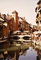
After a few meters, the river divides and encloses a spindle-shaped island, the top of which is built over with the Palais de l'Isle from the 12th century. The island, usually referred to only as "l'Île", once represented the only crossing over the Thiou with bridges on both sides. On its further course through the old town, the river is accompanied on the north side by the Quai de l'Évêché, which is only passable by pedestrians In the south, the development extends to the shore.
At the crossing Rue de la Republique follows another weir system, after which - north of a second island - the Canal du Vassé, once built to supply the defensive ditches with seawater, flows into the Thiou. The river then leaves the old town of Annecy at the level of Île Saint-Joseph. For several hundred meters it formed the border with the municipality of Cran-Gevrier , which was only connected to the city of Annecy since 2017. It crosses under the railway lines to Albertville and Aix-les-Bains and then winds through loosely built-up area. The construction of lateral channels to drive mill wheels resulted in three islands. Its confluence with the Fier is still in the area of Cran-Gevrier.
Harbor around 1900

L'Île (right) and Pont Perrière
Thiou in the old town of Annecy

Weir on the Rue de la République in Annecy

Weir between two islands in Cran-Gevrier

._(9762210592).jpg)


Web links
Individual evidence
- ↑ Le Thiou: Rivière de Haute Savoie at annecy-ville.fr, accessed on September 25, 2018
- ↑ Measured with Google Maps
- ↑ Histoire de la ville d'Annecy at annecy-ville.fr, accessed on 23 September 2018
- ↑ Ancienne papeterie Aussedat at musees.agglo-annecy.fr, accessed on September 25, 2018