Thurygrund
| Thurygrund | |
|---|---|
| coat of arms | map |

|

|
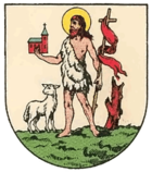
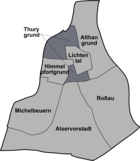
Thurygrund , also Thury , Thuryvorstadt and Am Thury , was an independent municipality ( suburb ) until 1850 and is now a district of Vienna in the 9th district of Alsergrund .
history
The Thurygrund area was already settled at the time of the Crusades . St. Johann an der Als , originally founded as a hospice for strangers, was probably already used as a hospital at this time . In 1179 a hospital was established to accommodate people suffering from leprosy . The name St. Johann an der Siechenals was subsequently transferred to the adjacent part of the Als and the settlement ( Siechenals ) adjacent to the brook . The associated church stood on a hill to the right of the Als, today's Arne-Karlsson-Park , until 1858 . Heinrich II. Jasomirgott , founder of the Schottenstift , transferred the property and parish rights to the Schottenkloster from Tiefen Graben to the Church of St. Johann and from there to the confluence of the Als in the Danube . During the first Turkish siege of Vienna , in order not to offer the attackers any cover or supplies, the church and the hospital of Siechenals with the village of the same name were set on fire. While the village of Siechenals was no longer built, the city council decided in 1540 to build a new hospital and to rebuild the St. Johann church.
The Thurygrund area subsequently remained uninhabited for a long time; in the middle of the 17th century, the district area was only populated as far as the lower reaches of the Als. In 1646, 117 years after Siechenals was destroyed, the brick manufacturer Johann Thury finally erected a building in this area for the first time. The area was repeatedly threatened by the floods of the Als, especially in the area of the confluence of the Währinger Bach at today's market hall. Thury owned two lots that were not connected. In 1656 he donated the northern part, which included a house with a vineyard , cellar and bar, as well as a brick oven on Sporkenbühel (Sparrow Hill) to the Servite Monastery. In memory of Johann Thury, the emerging suburb was finally named Thurygrund . While the southern part of the Thurygrund was already settled at the beginning of the 18th century, the northern part was dominated by brickworks for a long time. In the southern part, a chapel was built for the residents as early as 1713.
literature
- Czeike, Felix: Historical Lexicon Vienna in five volumes . Vienna 1997
- Wolf, Alfred: Alsergrund. District of Poets and Thinkers. Vienna 1993
- Wolf, Alfred: Alsergrund Chronicle. From Roman times to the end of the monarchy. Vienna 1981
Web links
Coordinates: 48 ° 14 ' N , 16 ° 21' E
