
Althangrund
| Althangrund | |
|---|---|
| coat of arms | map |

|

|
The Althangrund was an independent municipality ( suburb ) until 1850 and is now a district of Vienna in the 9th district of Alsergrund .
geography
The Althangrund lies in the northeast of the Alsergrund. In the north, the district borders on the Döblinger districts of Heiligenstadt and Oberdöbling , in the west on the Thurygrund and Lichtental and in the south on the Roßau . The Danube Canal forms the border in the east . The current boundaries to the parts of the district thus run from the Danube Canal to Alserbachstrasse no.27 , then follow Fechtergasse from no.16 to Althanstrasse , then continue across Lichtenwerder Platz to Heiligenstädter Strasse , Gürtelbrücke , Spittelauer Lände to Friedensbrücke .
history

The area of the Althanggrund was unpopulated for a long time. Spittelau, which belongs to the area, was awarded to the Bürgerspital as early as 1350, from which the wetland on the Danube Canal got its name. In 1679 seven barracks were built here to isolate those suffering from the plague from the population. The name Althangrund goes back to Christoph Johann Graf Althan , "Obrist-Hofkuchelmeister and Obrist-Hof-Landjägermeister ", who acquired the district part in 1690. Similar to Prince Liechtenstein in the neighboring Lichtental , Althan had a garden built on the Als and a pleasure house, the Palais Althan , by Johann Bernhard Fischer von Erlach . Althan died in 1706 and bequeathed his property to his son Gundacker von Althan , who sold the area to the Viennese magistrate in 1713. However, real settlement of the area did not begin until 1724, when a row of one-story houses was built in Althanstrasse 2 to 12 and was inhabited in particular by craftsmen. The palace itself initially turned out to be unprofitable property for the city of Vienna. In 1754 it was sold to the trader Johann Georg Schuller, his son Johann Baptist Pouthon, owner from 1777, had the palace rebuilt and the park converted into an English landscape park in the French style.
In a hiking guide from the Biedermeier period , the work “ Vienna's Environs for Twenty Hours in Circumferences ” by Adolf Schmidl (1835), an accident is described just inside the line wall of Nussdorf from 1779, which severely affected the Althangrund. An existing ammunition magazine there was blown up because of tobacco smoking or because of sparks from the nailed military shoes of an artilleryman and this explosion killed 25 "henchmen and constables" (non-commissioned officers in the artillery) as well as many uninvolved passers-by. The effects extended to the Brigittenau , the Augarten , the Schottenviertel and the Währing parish church , in the wall of which two spheres were built in memory. The sentry standing in front of the magazine escaped almost unharmed, apart from lifelong deafness.
- A bullet killed one of the horses of the prelate Ambros Lorenz von Klosterneuburg , which had just passed and remained undamaged, although he later died of the aftermath of the horror. He built this memorial column [called the "prelate column"] , and that ball is still preserved in the pencil.
This column stood at the corner of Althan and Liechtensteinstrasse; It was later dismantled for traffic reasons and rebuilt on the nearby Liechtenwerder Platz.
In the 19th century, Spittelau became the starting point for the first Viennese aqueduct that Ferdinand I had built. For this purpose, the groundwater of the Danube was taken from this area using suction channels and stored in water towers . Due to quality defects and insufficient capacity, however, the water pipeline was replaced 30 years later by the 1st Vienna High Spring Water Pipeline . The Spittelau waste incineration plant now stands in place of the machine house . In 1850, the entire area was finally integrated into the newly formed Alsergrund district and incorporated into Vienna.
In 1872 the Franz-Josefs-Bahnhof was built on the site of the former Althan-Pouthon Palace . From 1978 onwards, the University Center Althanstraße with the Vienna University of Economics and other institutions of the University of Vienna was built on the site of the freight station of the Franz-Josefs-Bahnhof .
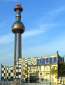
Spittelau waste incineration plant

Althan-Pouthon Palace (1720)

Franz-Josefs-Bahnhof

Peace Bridge


Personalities
- Josef Schwemminger (1804–1895), landscape painter
- Heinrich Schwemminger (1803–1884), history painter
literature
- Alfred Wolf: Alsergrund. District of Poets and Thinkers. Vienna 1993.
Web links
Individual evidence
- ^ Adolf Schmidl: Vienna's surroundings for twenty hours in a circle. Described by Adolf Schmidl after his own hikes. Printed and published by Carl Gerold, Vienna 1835, pp. 16, 73–74.
- ↑ Alsergrund Local History Museum. Bulletin of the Museumsverein Alsergrund 111. Vienna: Museumsverein Alsergrund 1989, p. 4 f.
Coordinates: 48 ° 13 ′ 48 ″ N , 16 ° 21 ′ 32 ″ E