
Tiétar
| Río Tiétar | ||
 |
||
| Data | ||
| location | Spain | |
| River system | Tagus | |
| Drain over | Tagus → Atlantic | |
| source | Puerto de la Venta del Cojo 40 ° 18 ′ 28 ″ N , 4 ° 31 ′ 27 ″ W. |
|
| Source height | approx. 750 m | |
| muzzle | in the Monfragüe National Park in the Tajo Coordinates: 39 ° 50 ′ 25 ″ N , 6 ° 1 ′ 38 ″ W 39 ° 50 ′ 25 ″ N , 6 ° 1 ′ 38 ″ W |
|
| Mouth height | approx. 265 m | |
| Height difference | approx. 485 m | |
| Bottom slope | approx. 1.3 ‰ | |
| length | approx. 380 km | |
| Catchment area | 4459 km² | |
| Small towns | Santa María del Tiétar , Sotillo de la Adrada | |
 Río Tiétar in front of the Sierra de Gredos |
||

The Río Tiétar is an approx. 380 km long northern tributary of the Tajo in the provinces of Ávila , Toledo and Cáceres in the autonomous regions of Castile-León , Castile-La Mancha and Extremadura in central Spain .
course
The Río Tiétar rises in the extreme east of the Sierra de Gredos in the municipality of Santa María del Tiétar in the province of Ávila in the autonomous region of Castile and León . It flows almost constantly in a south-westerly direction along the southern foothills of the up to 2592 m high Sierra de Gredos, all of the southern runoffs of which it collects, through sparsely populated areas. Its confluence with the Tagus is about 1 km south of the hamlet (pedanía) Villarreal de San Carlos in the province of Cáceres in the Extremadura region .
Tributaries and reservoirs
Numerous streams (arroyos) and smaller rivers (ríos) flow into the Río Tiétar, but they often run dry in summer and early autumn. The river is dammed twice:
- Embalse de Rosarito : height of the dam 252 m, catchment area (cuenca) 1754 km², max. Capacity 82 million m³
- Embalse de Torrejon-Tiétar : height of the dam wall 34 m, catchment area (cuenca) 4436 km², max. Capacity 12 million m³
Shore landscape
On the entire middle and lower reaches of the Río Tiétar there is not a single human settlement due to the rugged landscape and the dry bush forests that predominate there; its mouth is in the Monfragüe National Park , which has a large variety of birds of prey .
Attractions
The most important sights on the Río Tiétar include the medieval and early modern bridges Puente Mosquea , Puente Chico , Puente de La Iglesuela , Puente de Valdeolivas and Puente del Cardinal .
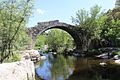
Roman Puente de La Iglesuela

Puente de Valdeolivas
Puente del Cardinal

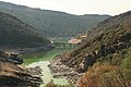
Confluence of the Río Tiétar (left) into the Río Tajo (right)


_04.JPG)
_12.JPG)
Comarca
The Comarca de Arenas de San Pedro is also sometimes referred to as the Comarca del Valle del Tiétar .