Tia River
| Tia River | ||
|
Tia River at Oxley Highway |
||
| Data | ||
| location | New South Wales , Australia | |
| River system | Macleay River | |
| Drain over | Apsley River → Macleay River → Tasman Sea | |
| source | Ngulin Nature Reserve in the Great Dividing Range 31 ° 20 ′ 0 ″ S , 151 ° 40 ′ 2 ″ E |
|
| Source height | 1360 m | |
| muzzle |
Apsley River in the south of Oxley Wild Rivers National Park Coordinates: 31 ° 5 ′ 55 ″ S , 151 ° 54 ′ 41 ″ E 31 ° 5 ′ 55 ″ S , 151 ° 54 ′ 41 ″ E |
|
| Mouth height | 457 m | |
| Height difference | 903 m | |
| Bottom slope | 17 ‰ | |
| length | 52 km | |
| Small towns | Tia | |
|
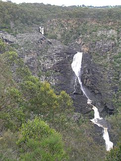
Tia Falls |
||
The Tia River is a river in the northeast of the Australian state of New South Wales .
geography
The river has its source on the northern plateau of New South Wales on the eastern slopes of the Great Dividing Range , around 19 km southeast of the small town of Tia . The Tia River flows northeast from its source to the small town of Tia and then crosses under the Oxley Highway . Immediately afterwards, he falls over the Tia Falls into the Oxley Wild Rivers National Park . There it flows into the Apsley River about 18 km northeast of Tia .
The entire course of the river is in the Walcha Local Government Area and Vernon County .
history
Previously the river was called Crimps Creek or Crockers River . The discoverer John Oxley had named the watercourse after the First Secretary of the Admiralty.
Agriculture and fishing
The land above the Tia Falls is considered a good pasture for raising cattle and sheep.
The Tia River is good fishing water for trout .
See also
Web links
- List of Placenames ASSIGNED as RIVERs . Geographical Names Register (GNR) of NSW. Geographical Names Board of New South Wales (July 16, 2012 memento on the Internet Archive )

