Tidan (river)
| Tidan | ||
|
Tidan at Vaholms brohus |
||
| Data | ||
| location | Jönköpings län , Västra Götalands län ( Sweden ) | |
| River system | Göta älv | |
| Drain over | Göta älv → Kattegat | |
| lake |
Strängseredsjön 57 ° 47 '41 " N , 13 ° 40' 6" O |
|
| Source height | 293 m above sea level | |
| muzzle | at Mariestad in Vänern Coordinates: 58 ° 42 '40 " N , 13 ° 49' 25" E 58 ° 42 '40 " N , 13 ° 49' 25" E |
|
| Mouth height | 45 m ö.h. | |
| Height difference | 248 m | |
| Bottom slope | 1.3 ‰ | |
| length | 187 km | |
| Catchment area | 2230 km² | |
| Drain |
MQ |
20 m³ / s |
| Flowing lakes | Jogen , Brängen , Nässjön , Stråken , Östen | |
| Small towns | Tidaholm , Tibro , Mariestad | |
| Communities | Kölingared , Madängsholm , Tidan | |
|
Tidan in Ryfors (Mullsjö municipality) |
||
|
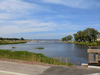
Mouth of the Tidan at Mariestad |
||
The Tidan is a Swedish river that has its source in the southern Swedish highlands and flows north through the Västergötland plain .
It has its origin in Lake Strängseredsjön at an altitude of 293 m . From there it first flows north and east through the Jogen , Brängen , Nässjön and Stråken lakes before flowing west of Lake Vättern and then passing the towns of Tidaholm and Tibro . In the lower reaches it flows through the lake Östen . It falls about 250 m on its course and flows into the Vänern at Mariestad . It is about 170 kilometers long and has an average water flow of 20 m³ / s.


