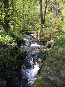
Tiefenbachtal near Simmerath with tributaries
|
NSG Tiefenbachtal near Simmerath with tributaries
|
||
|
The Tiefenbach in the middle to lower area |
||
| location | Simmerath , Aachen city region , North Rhine-Westphalia , Germany | |
| surface | 164.2 ha | |
| Identifier | ACK-086 | |
| WDPA ID | 319211 | |
| Natura 2000 ID | (partly) DE-5403-304 (partly) | |
| Geographical location | 50 ° 36 ' N , 6 ° 20' E | |
|
|
||
| Setup date | 2002 | |
| Framework plan | Landscape plan Simmerath | |
| administration | Lower landscape authority of the Aachen city region | |
The Tiefenbachtal near Simmerath with tributaries is a nature reserve (NSG identification ACK-086) in the North Rhine-Westphalian community of Simmerath . It is around 164.2 hectares and was designated in 2002 with the Simmerath landscape plan. The area includes the Tiefenbach from the source area to shortly before the confluence with the Rur, as well as tributaries and forest and grassland areas in the valley that adjoin the flowing waters .
With the exception of a few peripheral areas, the nature reserve lies almost entirely in the larger FFH area DE-5403-304 upper reaches of the Rur . This means that the relevant areas are part of the European Natura 2000 network of protected areas .
Area description
The Tiefenbach rises on the southwestern outskirts of Simmerath. Weckelbach and Emsenbach are the largest inflows on the way to the confluence with the Rur near Dedenborn .
The Tiefenbachtal consists of a deeply cut sole valley with natural mountain forests. Due to the very natural brook system with a brook bed made of coarse rubble and the very good water quality, the brook fauna is very species-rich. The Tiefenbach is fed by five source streams. The stream bed is between one and two meters wide. Meandering slightly, it also flows over small cascades to the valley. A little above the mouth of the Rur it feeds some fish ponds.
The last section of the Tiefenbach below the fish ponds to the mouth is in the adjacent Rurtal NSG with the rock formations of the Uhusley . To the south of the fish ponds, the NSG Brombachtal and Brommersbachtal border with a tributary .
Flora and fauna
The open areas in the upper reaches are grazed extensively. On the adjoining, lower slopes on the side of the slope, there are partially poor pastures with local spring swamps. In the Huppenbroich area , the poor pastures are lined with old beech hedges and bushed with ear willows and alders . In the middle and lower reaches even more extensive, old oak forests can be found.
The purpose of the nature reserve is also to preserve the diverse bird life. The kingfisher can be found here, as well as the black woodpecker and gray woodpecker .
See also
Web links
- Nature reserve "ACK-086 Tiefenbachtal near Simmerath with tributaries" in the specialist information system of the State Office for Nature, Environment and Consumer Protection in North Rhine-Westphalia

