Tjui
|
Tjui Тюй, Төй |
||
|
|
||
| Data | ||
| Water code | RU : 10010201112111100022807 | |
| location | Perm Region , Bashkortostan ( Russia ) | |
| River system | Volga | |
| Drain over | Ufa → Belaya → Kama → Volga → Caspian Sea | |
| source | in the Tulvinskaya Heights 56 ° 46 ′ 21 ″ N , 56 ° 16 ′ 12 ″ E |
|
| muzzle | in the Ufa dammed up to the Pavlovsk reservoir coordinates: 55 ° 56 ′ 31 ″ N , 57 ° 6 ′ 1 ″ E 55 ° 56 ′ 31 ″ N , 57 ° 6 ′ 1 ″ E
|
|
| length | 193 km | |
| Catchment area | 3700 km² | |
| Outflow location: 10 km above the mouth |
MQ |
18.1 m³ / s |
| Left tributaries | Sars | |
|
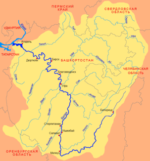
Location of the Tjui (Тюй) in the catchment area of the Belaja |
||
The Tjui ( Russian Тюй ; Bashkir Төй ) is a right tributary of the Ufa in the Perm region and in Bashkortostan in the European part of Russia .
The Tjui has its source in the Tulvinskaya Heights in the south of the Perm region. It flows in a south-southeast direction to Bashkortostan and flows into the Ufa after 193 km. The backflow of the Ufa through the Pavlovsk dam extends upstream to the mouth of the Tjui. 900 m above the confluence with the Ufa, the Sars meets the Tjui from the left. The Tjui drains an area of 3700 km². The Tjui is covered with ice between November and May. The mean discharge 10 km above the mouth is 18.1 m³ / s.
Individual evidence
- ↑ a b Tjui in the State Water Register of the Russian Federation (Russian)
- ↑ a b Article Tjui in the Great Soviet Encyclopedia (BSE) , 3rd edition 1969–1978 (Russian)
