Ufa (river)
|
Ufa Уфа, Ҡариҙел, Өфә (Öfä), Ӗпхӳ |
||
|
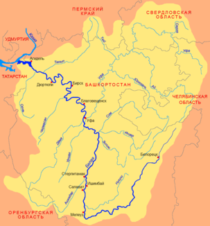
Location of the Ufa (Уфа) in the catchment area of the Belaya |
||
| Data | ||
| Water code | RU : 10010200812111100020106 | |
| location | Chelyabinsk Oblast , Sverdlovsk Oblast , Bashkortostan ( Russia ) | |
| River system | Volga | |
| Drain over | Belaya → Kama → Volga → Caspian Sea | |
| source | in the lake Ufimskoje near Karabash in the central Urals 55 ° 31 ′ 34 ″ N , 60 ° 7 ′ 3 ″ E |
|
| muzzle | in Ufa in the Belaja coordinates: 54 ° 40 ′ 41 ″ N , 55 ° 59 ′ 26 ″ E 54 ° 40 ′ 41 ″ N , 55 ° 59 ′ 26 ″ E
|
|
| length | 918 km | |
| Catchment area | 53,100 km² | |
| Drain |
NNQ MQ HHQ |
55 m³ / s 388 m³ / s 3740 m³ / s |
| Left tributaries | Ai , Jurjusan | |
| Right tributaries | Serga , Tjui | |
| Reservoirs flowed through | Pavlovsk reservoir | |
| Big cities | Ufa | |
| Medium-sized cities | Krasnoufimsk | |
| Ports | Krasnoufimsk , Ufa | |
|
Ufa in Bashkortostan |
||
The 918 km long Ufa ( Russian Уфа ; Bashkir Ҡариҙел ; Tatar Өфә / Öfä, Chuvash Ӗпхӳ ) is a right tributary of the Belaja in the European part of Russia .
course
The Ufa rises in the Middle Urals and flows first from its source in a north-westerly direction and then in a south-westerly direction. A long way after flowing through the Pavlovsk reservoir , the dam of which was built near Pavlovsk , it flows into the Belaya in the area of the city of Ufa .
The Trans-Siberian Railway temporarily uses the Ufa valley.
Web links
Commons : Ufa - collection of images, videos and audio files

