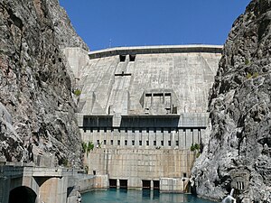
Toktogul dam
| Toktogul dam | |||||||||
|---|---|---|---|---|---|---|---|---|---|
| Dam wall | |||||||||
|
|||||||||
|
|
|||||||||
| Coordinates | 41 ° 39 '25 " N , 72 ° 38' 10" E | ||||||||
| Data on the structure | |||||||||
| Construction time: | 1962-1975 | ||||||||
| Height above foundation level : | 215 m | ||||||||
| Building volume: | 3.345 million m³ | ||||||||
| Crown length: | 293 m | ||||||||
| Power plant output: | 1 200 MW | ||||||||
| Data on the reservoir | |||||||||
| Water surface | 284.3 km² | ||||||||
| Storage space | 19,500 million m³ | ||||||||
The Toktogul Dam is the largest dam in Kyrgyzstan . It was in 1975 at the central Naryn , a tributary of the Syr Darya , built and named after Toktogul Satylganov (1864-1933) and after the city Toktogul , which lies east of the reservoir. The dam is part of the Naryn-Syrdarja cascade.
The barrier structure is a 215 meter high concrete gravity dam . The reservoir is 65 km long and has an area of 284 km² and a storage volume of 19.5 billion m³ (19.5 km³). Of this, 14 billion m³ can be effectively used. The main purposes of the dam are power generation, irrigation and flood protection. With the installed capacity of 1200 MW , around 4100 GWh of electricity are generated annually.
irrigation
With the construction of the dam, the former Soviet Union was able to supply 800,000 ha of existing irrigation area in Uzbekistan and Kazakhstan and develop 480,000 ha of additional land. The water is taken through the Great Namangan Canal with a capacity of 60 m³ / s and the Left Naryn Canal with 20 m³ / s.
When the reservoir was flooded in 1976, 24 or 26 places in the Ketmentub Valley (Ketmen-Tjubinsk Valley) were flooded and relocated along the main road that had been moved to the east bank. An agricultural area of 21,200 ha, of which 12,500 ha was irrigated, was also lost. In compensation for these losses, Kyrgyzstan received agricultural products, gas and consumer goods. Archaeologists found several burial mounds from the 8th and 9th centuries before the flooding.
Interstate water use
The dam is very close to the border with Uzbekistan. Therefore, the benefits of irrigation and flood protection mainly benefit Uzbekistan, but are controlled by Kyrgyzstan. For this reason there are contractual agreements, but also disputes between the two neighboring countries.
According to an agreement from 1984, 25% of the amount of water (for power generation) and in summer 75% of the amount of water (for irrigation) were to be given away (the actual average for the years 1985–91 was 31% to 69%.) In exchange For the supplied water and the abundance of electricity, Uzbekistan and Kazakhstan were supposed to balance the energy requirements in Kyrgyzstan from their fossil fuel power plants in winter. With independence in 1991, this system was thrown out of whack, and due to the inability to pay world market prices for fossil fuels, the discharge was increased to 66% in winter in 1993 and decreased to 34% in summer to generate more energy. As a result, there is now too little water in the middle and lower reaches of the Syr Darja , the Ferghana Valley in Uzbekistan and Kazakhstan. In the years 1998, 2001 and 2004–2005, Kyrgyzstan is said to have not complied with the quotas to the detriment of agriculture downstream.
In addition, there are now floods in the lower reaches of the Syrdarja in Kazakhstan in winter, which is why part of the runoff into the Aydarsee in Uzbekistan has to be diverted. As a result, the Aral Sea , into which the Syr Darya flows, is drying up more and more.
Others
The Toktogul dam is depicted on Kyrgyzstan's 100 som notes from 1994 and 2009.
See also
- List of power plants in Kyrgyzstan
- List of dams in the world (Kyrgyzstan)
- List of the largest dams on earth
- List of the largest reservoirs on earth
Web links
- UNEP, UNDP, OSCE and NATO: Environment and Security: Transforming risks into cooperation - Central Asia - Ferghana / Osh / Khujand area (downloadable as PDF)
- Interstate water use conflicts in Central Asia (PDF file; 718 kB)
- Operation of the Toktogul Reservoir (PDF file; 126 kB)
- Photos: At the Toktogul reservoir , road to nowhere

