Aydar Sea
|
Aydarsee Haydarkoʻl, Aydar koʻli, Aydarkul |
||
|---|---|---|

|
||
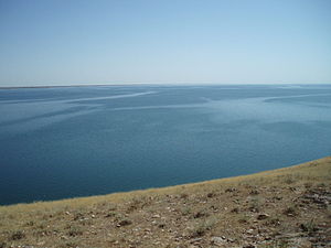
| Looking east from the extreme northwest | ||
| Geographical location | Desert Kyzyl Kum in Uzbekistan | |
| Tributaries | derived amounts of water from the Syrdarya , Kyly , sewage collectors from the Golodnaya steppe | |
| Drain | drainless ( pelvic position ) | |
| Location close to the shore | Taldy, Baymurat, Koshquduq, Darbaza | |
| Data | ||
| Coordinates | 40 ° 55 ' N , 66 ° 48' E | |
|
|
||
| Altitude above sea level | 247 m (2011) | |
| surface | 3600 km² (2011) | |
| length | 180 km | |
| width | 32 km | |
| volume | approx. 44.3 km³ | |
| Maximum depth | 40 m | |
|
particularities |
unintentionally man-made lake |
|

|
||
| Satellite image with Lake Aydar in the middle | ||
The Aydarsee (Uzbekistan Haydarko'l or Aydar ko'li , Cyrillic Айдаркўл ) is a - as an unintended by-product of Soviet planning incurred by man - See in Uzbekistan in the southeastern Kysylkum and is mainly determined by water from the Syrdarja fed. Most of the lake is in Jizzax Province , the western part in Navoiy Province . This lake is the result of the 4,000 km² Aydar-Arnasay lake system .
prehistory
Until the middle of the 20th century, the lowlands of Arnasay - in the area of the inflow from the Syr Darya - were for most of the year a dry salt pan with some periodic brackish water lakes . Only in the spring - in the extreme southeast of today's lake - the periodically fed by the river Kyly and at that time without drainage, the small lake Tuzkan could form, which, however, quickly evaporated again at hotter temperatures.
Emergence
In the early 1960s, the Syr Darya was dammed and the Schardara dam was built just beyond the border with Kazakhstan , which was provided with an emergency overflow into the lowlands of Arnasay in order to be able to control floods. In 1969 this had to be opened in the course of a flood disaster, because the capacity of the dam was not suitable for controlling the water masses. From February 1969 to February 1970 almost 60 percent of the average annual runoff of the Syr Darya (22 km³) was diverted from the Shardara reservoir into the Arnasay lowlands. After that, the lake level was 239.4 m; the area grew to 2,300 km² and the volume to 20 km³. By the end of the 1970s, the lake level sank again by four meters. The salt content was around 8–10 g / l. In the 80s the lake level was kept in an artificial equilibrium.
In years with abundant rainfall, up to 7.5 km³ of water was lost for irrigation in this way; as a result, the natural depression filled in the course of time, creating the largest lake in the region. This development is comparable to the formation of the Toshka lakes in Egypt.
Since the end of the Soviet Union, the neighboring states have been regulating water consumption increasingly selfishly, e.g. For example, Tajikistan stores water in summer and uses it more in winter to generate electricity, so that the artificial flood - which coincides with the melting of the snow - would often overload the Kazakh Shardara dam and more water is drained into Lake Aydar.
At the end of the Soviet Union, the lake level was relatively constant at 236 m. In spring 1991 it rose for the first time by about one meter and covered an area of about 2320 km². The snowmelt in the winter of 1992/1993 caused the lake to rise by about two meters within a month, the next snowmelt in the spring of 1994 by a further three meters to 242 m; This year the land bridge between Lake Tuzkan and Lake Aydar was completely flooded and has since been directly connected to the Arnasay Lake system. In June 1998 the volume of the lake had increased from a level of 244 m to 32 km³ and the area to 3,067 km². Large stretches of land that had previously been used mainly as pastures were lost due to the rise in the lake level.
The rise of the lake caused problems with the discharge of sewage from the irrigation areas, the destruction of dams, roads and railways on the one hand, but significant improvements for fishing on the other.
In the meantime the Aydarsee has reached a length of about 180 kilometers and a width of up to 32 kilometers. The villages of Baymurat, Koshquduq, Darbaza and others are at risk of flooding. In some cases dams had to be built to prevent this ( 41 ° 7 ′ 7 ″ N , 66 ° 23 ′ 32 ″ E ) .
The floods in February 2005 prompted the Uzbek government to ask Kazakhstan to reduce the discharge of water into the valley and to build a dam to control the inflow itself ( 40 ° 58 ′ 37 ″ N , 67 ° 58 ′ 15 ″ E ) . For Kazakhstan, there is a risk of the Shardara dam rupture and flooding of numerous cities and settlements on the Syr Darya.
Geography and bathymetry
The newly created lake is bounded in the east by the Golodnaya Steppe (Uzbek Mirzacho'l ) and in the southwest by the foothills of the Nurota Mountains, while to the north it penetrates the dunes of the otherwise flat Kyzylkum desert.
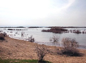
The northern bank is therefore very dissected; islands and peninsulas extend up to half of the lake. The area of the former Arnasay lakes and the northern part is rather flat with a depth of a few meters, while in the southern half and in the area of the former Tuzkan lake up to 40 meters can be reached.
Future development
Since 2005 the height of the lake level has only fluctuated slightly; however, if the level rises a few meters further - approximately to the level of the Schardara Reservoir (252 m) - the former depression will be completely filled. This makes it more likely that water will flow north into areas of the Kyzylkum desert that have not seen surface water for millennia. This is currently only prevented by the dune belt north of the lake, which the lake is already beginning to break through, as the penetration into settlement areas and the construction of dams there shows. In this way, it would be possible in the future to form a new river course between Amu Darya and Syr Darya up to the remnants of the Aral Sea ; some scientists even suspect a glacial valley of the Syrdaria here.
fishing
The mineralization of the lake water averages a comparatively low 2,000 ppm . Numerous species of fish have been released in Lake Aydar, such as pikeperch , bream , catfish , carp , asp , sickling and the Channa argus . Between 1994 and 2001, the fishing industry created on the lake caught between 760 and 2000 tons of fish annually.
natural reserve
In addition to the fauna typical of the Kyzylkum, there are various water birds at the Aydar Sea , which migrate here from the Aral Sea. The lake is included in the Ramsar List as an Important Bird Area, it is located at the intersection of the Afro-Eurasian and Central Asian trajectories and is a center for the migration and wintering of waterfowl of more than 100 species, providing habitat for threatened species like the white-headed duck (Oxyura leucocephala), the Sociable Lapwing (Chettusia gregaria), the Dalmatian Pelican (Pelecanus crispus), the red-breasted goose (Rufibrenta ruficollis), the Zwerggans (Anser erytropus) and Pallas's Fish Eagle (Haliaetus leucoryphus), providing an important source of food and a spawning ground for different Fish species. The most important forms of vegetation are the reed belts, salt herbs and tamarisk trees used by the locals . An action plan to maintain the stability of ecological conditions, 2008–2015, is in place.
tourism
The lake is largely away from inhabited areas; currently only about 345 families or 1,760 people live near Lake Aydar. This quiet location and the possibilities for fishing , camel rides and yurt overnight stays in the region are the tourist attractions of the lake.
Web links
- Information on pagetour.narod.ru (English)
Individual evidence
- ^ M. Groll (Philipps-Universität, Marburg, Germany) R. Kulmatov (National University of Uzbekistan, Tashkent, Uzbekistan) N. Mullabaev (National University of Uzbekistan, Tashkent, Uzbekistan) A. Belikov (National University of Uzbekistan, Tashkent, Uzbekistan) Ch. Opp (Philipps-Universität, Marburg, Germany) D. Kulmatova (National University of Uzbekistan, Tashkent, Uzbekistan): Rise and Decline of the fishery industry in the Aydarkul-Arnasay lake system (Uzbekistan) - effects of reservoir management , irrigation farming and climate change on an unstable ecosystem. In: CDZ Symposium on Lake-catchment interactions and their responses to hydrological extremes, Nanjing. Phillips University of Marburg, October 10, 2015, accessed on February 28, 2017 .
- ↑ A. Ryabtsev, M. Yeliseev: Report 3 Preliminary Environmental Impact Assessment (Pre-EIA) (Book 1). In: Syrdarya Control and Northern Aral Sea, Phase-2 (SYNAS-2) Feasibility Study. Republic of Kazakhstan Ministry of Environment and Water Resources Committee for Water Resources, 2014, pp. 26-27 , accessed on March 23, 2017 .
- ↑ Wahyuni S., Oishi S., Sunada K., Toderich KN, NE Gorelkin: Analysis of water-level fluctuations in Aydarkul-Arnasay-Tuzkan Lake System and its impacts on the surrounding groundwater level. In: Annual Journal of Hydraulic Engineering, Vol. 53. Japan Society of Civil Engineers, February 2009, accessed September 6, 2017 .
- ↑ About the situation around the Arnasay Lakes. The position of Uzbekistan. Retrieved September 7, 2017 (Russian).
- ↑ Central Asia Report: February 16, 2004. Retrieved March 1, 2017 .
- ↑ Depression of Lake Aydar. In: Flood Map: Water Level Elevation Map. Sameer Burle, accessed February 28, 2017 .
- ↑ Ibrohim Mo'minov: Aydar sho ' rxoki . In: Usbekische Soviet Encyclopaedia (O ' Zbęk sovet ensiklopediyasi) . Tashkent 1971, p. 189 f .
- ^ The Ramsar List of Wetlands of International Importance (PDF)


