
Bidarray
|
Bidarray Bidarrai |
||
|---|---|---|

|
|
|
| region | Nouvelle-Aquitaine | |
| Department | Pyrénées-Atlantiques | |
| Arrondissement | Bayonne | |
| Canton | Montagne Basque | |
| Community association | Pays Basque | |
| Coordinates | 43 ° 16 ′ N , 1 ° 21 ′ W | |
| height | 61-935 m | |
| surface | 38.20 km 2 | |
| Residents | 677 (January 1, 2017) | |
| Population density | 18 inhabitants / km 2 | |
| Post Code | 64780 | |
| INSEE code | 64124 | |
| Website | www.garazibaigorri.com/fr/le-territoire/bidarray.html | |
 View of Bidarray from the west |
||

Bidarray is a French municipality with 677 inhabitants (at January 1, 2017) in the department of Pyrénées-Atlantiques in the region Nouvelle-Aquitaine (before 2016: Aquitaine ). The municipality belongs to the Arrondissement of Bayonne and the canton of Montagne Basque (until 2015: canton of Saint-Étienne-de-Baïgorry ).
The inhabitants are called bidarraitars . The name in the Basque language is Bidarrai .
geography
Bidarray is located approx. 40 km southeast of Bayonne in the Lower Navarra region in the French part of the Basque Country . The municipality borders in the southwest on the Autonomous Community of Navarre in northern Spain . The town center is on the left bank of the Nive , slightly elevated on a hill at the confluence of the Bastan and the Nive. The highest point in the municipality is the Larrateko Hegia (935 m) on the Spanish border.
The place is surrounded by the neighboring communities:
| Itxassou |
Louhossoa Macaye |
Ossès |
.svg)
|
||
|
Saint-Étienne-de-Baïgorry Saint-Martin-d'Arrossa |
Bidarray is located in the catchment area of the Adour River . The Nive, one of its tributaries, crosses the municipality with its tributaries
- Askétako Erreka,
- Arantko Erreka with its tributary Errariko Erréka and
- Le Bastan, also called Urritzateko Erreka.
history
The first mentions in the Middle Ages refer to a small commandery of the monastery of Roncesvalles with its Romanesque chapel , which was built near the current church towards the end of the 12th century to receive pilgrims on the Way of St. James to Santiago de Compostela . According to Jean-Baptiste Orpustan's Nouvelle toponymie basque, Bidarray was named Bidarray in 1268 and 1292 , along with the chapel and pilgrims' hostel . According to Paul Raymond, archivist and historian of the 19th century, the place was mentioned in 1621 in connection with La comienda de Vidarray .
The wooded area was not permanently inhabited until the 16th century. In 1665 the commandery was handed over to the von Ossès family, and in 1723 the parish became independent from Ossès. The municipality is entered as Bidarray on the map of Cassini 1750 . In 1790 the place was detached from Ossès as a municipality. During the French consulate in 1801, Bidarray was run as Bidarray as well as Bidarroy .
coat of arms
According to Guy Ascarat, heraldist and historian, the coat of arms can be interpreted as follows.
The two mussel shells are pilgrim shells and indicate the location on the Way of St. James, the bishop's staff to the commandery of the Augustinians of Roncesvalles.
Population development
After the population peaked at the beginning of the 19th century with over 1400 inhabitants, the rural exodus began and reduced the number in waves to less than half by the 1990s. Since then, the number has been increasing again due to trade and tourism .
| year | 1962 | 1968 | 1975 | 1982 | 1990 | 1999 | 2006 | 2009 | 2017 |
|---|---|---|---|---|---|---|---|---|---|
| Residents | 745 | 714 | 673 | 631 | 585 | 645 | 637 | 633 | 677 |

Attractions


- Church dedicated to the Assumption of Mary . Of the Romanesque chapel of the commandery, the choir , the apse with its blind arcades and the entrance portal can still be seen on the current building. In 1625 the nave was lengthened and the transept and bell gable were built in their baroque, round shape. Further alterations were made in the 19th century. The walls of the nave and the choir were raised, new window openings were broken and the ceiling inside was equipped with a ribbed vault . The choir received the original decoration with Romanesque blind arcades. In the second half of the 20th century, new stained glass windows a . a. used by Mauméjean stained glass from Biarritz . With its red sandstone walls and the round apse, the exterior of the church differs from other sacred buildings in the Basque Country. However, it shares with them a main nave with several galleries inside, which of this church can be reached from an external brick staircase on the north and south sides.
- Noblia Bridge. The medieval bridge was built in the 14th century and was used by the St. James pilgrims until the 17th century to get to the other side of the Nive and thus to the priory of Roncesvalles. Today's bridge crosses the river over three arches. The middle arch had to be rebuilt in the 17th century after it was damaged in a flood of the Nive. In 1822 the entire bridge was restored. The northernmost arch was destroyed in 1895 during the construction of the railway line from Bayonne to Saint-Jean-Pied-de-Port .
- Ferme Gastetto, built towards the end of the 17th century or the beginning of the 18th century. The function of the floors of the farmhouse is divided as in all farms in Navarre. The ground floor is used to accommodate the animals and agricultural equipment, the first floor consists of living rooms and the top floor houses the hayloft. The balcony above the first floor, on which the seeds are traditionally dried, is typical of the region’s farmhouses . An annex on this farm also offers space for a hen house and a pig house.
- Other old farms from the 18th century on the territory of the municipality are registered as national cultural assets:
- Ferme Garbelania
- Ferme Antxordokia
- Ferme Marmaroa
- Ferme Topene Zaharra
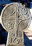
- Hilarri . In the Bidarray cemetery there are several of these disc-shaped funerary steles, which are based on the tradition of the pre-Christian era and were very popular in the Basque Country between the 16th and 18th centuries. These traditional steles are made of one stone, some with vegetal, religious or sun ornaments, and were placed on the head of the dead against the rising sun. The name of the deceased always remains anonymous. In the cemetery in Bidarray there are steles with Basque crosses , stars with six points for the six days of a week excluding Sunday, but also steles with concentric circles.
- Hilarri in the Bidarray cemetery


.jpg)
.jpg)
.jpg)
.jpg)
.jpg)
.jpg)
.jpg)
.jpg)
Economy and Infrastructure

The following factors determine the economic life of the municipality: Agriculture, especially sheep breeding, trade, tourism and handicrafts. Bidarray is located in the AOC zones of the wine-growing region of the Irouléguy , the Ossau-Iraty , a traditionally made semi-hard cheese made from sheep's milk, as well as the pig breed and the ham "Kintoa".

total = 94

Sports
The water of the Nive is ideal for kayaking and rafting tours. There are several providers in town for this.
The GR 10 long-distance hiking trail from Hendaye on the Atlantic to Banyuls-sur-Mer on the Mediterranean leads through the municipality. Bidarray is the starting point of many other hiking trails in the surrounding mountains, which are home to one of the most important colonies of wild griffon vultures in Europe.
education
Bidarray has a public primary school.
traffic
Bidarray is crossed by Route départementale 918, the former Route nationale 618 .
Line 62 of the TER Aquitaine , a regional train of the national SNCF , serves the route from Bayonne to Saint-Jean-Pied-de-Port. A stop in Bidarray is on the opposite side of the Nive, seen from the town center.
Personalities
- Jean-Baptiste (also Joannes or Yoanes) Oxalde, Basque Joanes Otsalde, born on September 28, 1814 in Bidarray, died on December 13, 1897, wrote poetry in the Basque language. He won several prizes in the poetry contest , including in Sare in 1868 with his poem Enperatrizari (German: Empress), which he wrote to Eugénie de Montijo , the wife of the French Emperor Napoleon III. , dedicated.
- Jules Moulier, born April 7, 1888 in Bidarray, died on February 7, 1958 in Bayonne, was a priest , Bertsolari, poet, writer and member of the Royal Academy of the Basque Language . A Bertsolari (German: poet) is a singer of verses in the Basque language, improvising in front of an audience.
Web links
- Saint-Jean-Pied-de-Port and Saint-Étienne-de-Baïgorry Tourist Office website (French)
- Website of the AOP Ossau-Iraty association (French)
- Filière Porc Basque website (French)
- Bidarray on the map by Cassini 1750
Individual evidence
- ↑ Pyrénées-Atlantiques Gentile ( fr ) habitant.fr. Retrieved March 3, 2017.
- ↑ Lieux - toponymie: Bidarrai (Baigorri-Ortzaize) ( fr ) euskaltzaindia . Retrieved March 3, 2017.
- ↑ géoportail ( fr ) Institut national de l'information géographique et forestière . Retrieved March 3, 2017.
- ↑ Ma commune: Bidarray ( fr ) Système d'Information sur l'Eau du Bassin Adour Garonne. Retrieved March 3, 2017.
- ↑ a b Guy Ascarat: Armorial Communes Basques ( fr ) Archived from the original on August 7, 2016. Retrieved on March 3, 2017.
- ^ Jean-Baptiste Orpustan: Nouvelle toponymie basque ( fr ) University of Bordeaux . P. 126. 2006. Retrieved March 3, 2017.
- ^ Paul Raymond: Dictionnaire topographique du département des Basses-Pyrénées ( fr ) In: Dictionnaire topographique de la France . Imprimerie nationale. P. 31. 1863. Retrieved March 3, 2017.
- ^ France 1750 ( en ) David Rumsey Map Collection: Cartography Associates. Retrieved March 3, 2017.
- ↑ présentation de la commune de Bidarray ( fr ) Ministry of Culture and Communication . Retrieved March 3, 2017.
- ↑ a b Notice Communale Bidarray ( fr ) EHESS . Retrieved March 3, 2017.
- ↑ Populations légales 2006 Commune de Bidarray (64124) ( fr ) INSEE . Retrieved March 3, 2017.
- ↑ Populations légales 2014 Commune de Bidarray (64124) ( fr ) INSEE . Retrieved March 3, 2017.
- ↑ église paroissiale de l'Assomption ( fr ) Ministry of Culture and Communication . Retrieved March 3, 2017.
- ^ Conseil regional d'Aquitaine: Église de l'Assomption ( fr ) Visites en Aquitaine. Archived from the original on March 3, 2017. Info: The archive link was inserted automatically and has not yet been checked. Please check the original and archive link according to the instructions and then remove this notice. Retrieved March 3, 2017.
- ↑ Pont Noblia sur la Nive ( fr ) Ministry of Culture and Communication . Retrieved March 3, 2017.
- ^ Conseil regional d'Aquitaine: Ferme Gastetto ( fr ) Visites en Aquitaine. Archived from the original on March 3, 2017. Info: The archive link was inserted automatically and has not yet been checked. Please check the original and archive link according to the instructions and then remove this notice. Retrieved March 3, 2017.
- ↑ Conseil régional d'Aquitaine: Cimetière de Bidarray ( fr ) Visites en Aquitaine. Archived from the original on March 3, 2017. Info: The archive link was inserted automatically and has not yet been checked. Please check the original and archive link according to the instructions and then remove this notice. Retrieved March 3, 2017.
- ↑ a b BIDARRAY: La commune ( fr ) Communauté d'agglomération du Pays Basque . Retrieved March 3, 2017.
- ↑ Institut national de l'origine et de la qualité ( fr ) Institut national de l'origine et de la qualité . Archived from the original on February 5, 2017. Info: The archive link was inserted automatically and has not yet been checked. Please check the original and archive link according to the instructions and then remove this notice. Retrieved March 3, 2017.
- ↑ Caractéristiques des établissements en 2014 Commune de Bidarray (64124) ( fr ) INSEE . Archived from the original on March 4, 2017. Info: The archive link was inserted automatically and has not yet been checked. Please check the original and archive link according to the instructions and then remove this notice. Retrieved March 3, 2017.
- ↑ GR®10: la traversée des Pyrénées ( fr ) Comité Régional de la Randonnée Pédestre Midi-Pyrénées. Retrieved March 3, 2017.
- ↑ Regional Council of Aquitaine: Bidarray ( fr ) Visites en Aquitaine. Archived from the original on March 3, 2017. Info: The archive link was inserted automatically and has not yet been checked. Please check the original and archive link according to the instructions and then remove this notice. Retrieved March 3, 2017.