
Itxassou
|
Itxassou Itsasu |
||
|---|---|---|
.svg)
|
|
|
| region | Nouvelle-Aquitaine | |
| Department | Pyrénées-Atlantiques | |
| Arrondissement | Bayonne | |
| Canton | Baïgura et Mondarrain | |
| Community association | Pays Basque | |
| Coordinates | 43 ° 20 ′ N , 1 ° 25 ′ W | |
| height | 131-926 m | |
| surface | 39.37 km 2 | |
| Residents | 2,133 (January 1, 2017) | |
| Population density | 54 inhabitants / km 2 | |
| Post Code | 64250 | |
| INSEE code | 64279 | |
| Website | www.itxassou.fr | |
 Main street in Itxassou |
||

Itxassou ( Basque : Itsasu ) is a commune in the French Basque Country with 2,133 inhabitants (1 January 2017) in Pyrénées-Atlantiques in the region Nouvelle-Aquitaine . It belongs to the Bayonne arrondissement and the Pays Basque municipal association .
geography

View over Itxassou to the 926 m high Artzamendi
|

Nive - tributary Ruisseau du Laxia
|
The municipality of Itxassou is located in the south of the historic Labourd Province in the western Pyrenees , 19 kilometers southeast of the coastal town of Bayonne . The municipal area of Itxassou comprises a section of the Nivetal and the surrounding foothills of the Pyrenees. The Nive breaks through a last mountain barrier on its course to the north at the height of Itxassou and forms up to 250 m high rocky banks before it enters a flatter terrain with a lower flow velocity from Cambo-les-Bains . In the district of Laxia , the approximately eight-kilometer-long mountain river Ruisseau du Laxia flows into the Nive. In the headwaters of the Ruisseau du Laxia near the Spanish border, the Artzamendi rises , with 926 m the highest point in the municipality of Itxassou.
Itxassou includes the districts and hamlets Le Bourg, Tellery, Errobi, Errobisola, Laxia, Haranéa, Orkazberroa and Olhaénéa .

Itxassou is bordered by Cambo-les-Bains in the north, Louhossoa in the east, Bidarray in the southeast, Baztan (Spain) in the south and Espelette in the west .
history
The Basque name Itsasu comes from the Basque word for broom ( Itsas, Itxas ). In 1264 the place appears as Ytssassu . In the topographical dictionary Bearn-Basque of 1863 the municipality is called Itsatsou . In 1453 - during the reign of Charles VII - Itxassou came to France with the entire province of Labourd as Domaine royal (crown domain).
The Gorria cultivation came to Itxassou around 1650 .
Population development
| year | 1962 | 1968 | 1975 | 1982 | 1990 | 1999 | 2007 | 2017 | |
| Residents | 1134 | 1175 | 1218 | 1297 | 1563 | 1770 | 1998 | 2133 | |
| Sources: Cassini and INSEE | |||||||||
Attractions

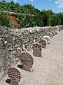
- several cromlechs , stone circle-like megalithic formations from the Neolithic or Bronze Age :
- Cromlech d'Arluxatta , Monument historique
- Cromlech d'Iuskadi , Monument historique
- Cromlech de Meatse , Monument historique
- Cromlech de Meatseko-Biskarra , Monument historique
- Cromlechs de Zelaïou , Monument historique
- Pas de Roland , a rock gate on the right bank of the Nive, according to legend, carved into the rock by Roland with his Durendal sword .
- Rabbit and Guinea Pig Park, open from June 15th to September 30th.
- Airfield at Mont Urzumu with a 360 ° viewpoint
- Rafting station at the level bridge
- 926 m high summit of Artzamendi , to which a road leads up (panoramic view)
church
- Church of St. Fructuosus in Itxassou

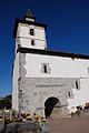


The church of St. Fructuosus ( Église Saint-Fructueux ) dates from the 17th century. It is with its interesting interior (forum and gallery on three floors with wood carvings), and sculptures around the church classified as a monument historique .
Economy and Infrastructure
In Itxassou there are not only many agricultural businesses but also numerous craft and service companies as well as small and medium-sized industrial companies. The latter have particularly settled in the commercial zone ( zone d'activité ) Errobi. Nationally known is the community for the Gorria production - a chili -Varietät that freshly ground or powder in the Basque cuisine is not indispensable is ( Bacalao a la Vizcaina , cod in chili sauce; Chorizo a la Sidra , cooked chorizo in cider). Other specialties are the cherries from Itxassou, which can even be seen on the municipality's coat of arms, and Ossau-Iraty , a traditionally made sheep's cheese. Every Thursday is market day on the Place du Fronton in Itxassou. There are 107 farms in the community (growing of cereals, vegetables, fruits and herbs, dairy farming, beekeeping, breeding of horses, cattle, sheep, goats and poultry). Tourism has also developed in Itxassou in the meantime. There are currently 1128 beds available in hotels, guest houses and holiday apartments. There is also a campsite with 228 spaces.
The trunk road leads through Itxassou from the agglomeration of Bayonne - Anglet - Biarritz up the Nivetal to Saint-Jean-Pied-de-Port . The railway line from Bayonne to Saint-Jean-Pied-de-Port, completed in 1898, runs parallel to the trunk road. Itxassou station is on the right bank of the Nive. There are other road links to Espelette and Cambo-les-Bains .
supporting documents
- ^ Paul Raymond: Dictionnaire Topographique du Département des Basses-Pyrénées. Imprimerie Impériale, Paris 1863, ( digitized ).
- ↑ Léon Mirot, Albert Mirot: Manuel de géographie historique de la France. Volume 1: L'unité française. New edition of the 2nd edition 1947. Picard, Paris 1979, ISBN 2-7084-0033-9 .
- ↑ "/ Piment d'Espelette - Ezpeletako Biperra (French)
- ↑ Itxassou on cassini.ehess.fr
- ↑ Itxassou on insee.fr
- ↑ Sights on itxassou.fr (French)
- ^ Entries in the Base Mérimée of the Ministry of Culture. Retrieved January 26, 2013 (French).
- ^ Entry in the Base Mérimée of the Ministry of Culture. Retrieved January 26, 2013 (French).
- ↑ Farms on annuaire-mairie.fr, 4 pages (French)
- ↑ Economic data on itxassou.fr (French)