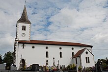
Arraute-Charritte
|
Arraute-Charritte Arrueta-Sarrikota |
||
|---|---|---|

|
|
|
| region | Nouvelle-Aquitaine | |
| Department | Pyrénées-Atlantiques | |
| Arrondissement | Bayonne | |
| Canton | Pays de Bidache, Amikuze et Ostibarre | |
| Community association | Pays Basque | |
| Coordinates | 43 ° 24 ′ N , 1 ° 6 ′ W | |
| height | 8-182 m | |
| surface | 22.81 km 2 | |
| Residents | 385 (January 1, 2017) | |
| Population density | 17 inhabitants / km 2 | |
| Post Code | 64120 | |
| INSEE code | 64051 | |
 Bakery in Arraute-Charritte |
||
Arraute-Charritte is a French municipality with 385 inhabitants (at January 1, 2017) in the department of Pyrénées-Atlantiques in the region Nouvelle-Aquitaine . The municipality belongs to the Bayonne arrondissement and the canton of Pays de Bidache, Amikuze et Ostibarre (until 2015: canton of Saint-Palais ).
The inhabitants are called Arruetar or Sarrikotar . The name in the Basque language is accordingly Arrueta-Sarrikota .
geography
Arraute-Charritte is located about 45 kilometers southeast of Bayonne in the French part of the Basque Country . It is part of the Pays de Mixe, a high valley of the Bidouze in the historical region of Lower Navarra .
The place is surrounded by the neighboring communities:
|
bidache Came |
||
| Orègue |

|
Bergouey-Vlichenave Arancou |
|
Masparraute Cupid's Succos |
Arraute-Charritte is located in the Adours catchment area . The Bidouze flows along part of the eastern municipal boundary. The Sarrot, Mendehéguy and Sanseroy rivers arise in the local area, as does the Lamulary, a tributary of the Minhurrieta erhka. Two tributaries of the Lihourys , the Oyhanchoury and the Pataréna, as well as their tributary, the Bordaberry, also irrigate the area of the municipality.
history
Arraute was first mentioned in 1125 with the same name, the first mentions of Charritte were made around 1160 as sanctus joannes de sarricte in connection with the name of the local church.
Since the Middle Ages, the two villages have been under the influence of noble families, the Arraute and Iturrondo. Arraute-Charritte is on the border with the Béarn . The peasant population often moved from one side to the other in search of work or markets, so that the inhabitants of Charitte spoke both Basque and the dialect des Béarn.
On June 27, 1842, the communities of Arraute and Charritte merged to form today's commune.
Population development
The number of inhabitants has steadily more than halved since the unification of the earlier municipalities, especially in the 20th century. The trend has stopped since 1999 and the population has increased slightly since then.
| year | 1962 | 1968 | 1975 | 1982 | 1990 | 1999 | 2006 | 2009 | 2014 |
|---|---|---|---|---|---|---|---|---|---|
| Residents | 471 | 444 | 418 | 376 | 365 | 322 | 322 | 365 | 378 |
Attractions
- Local church Saint-Pierre von Arraute, dedicated to the apostle Simon Petrus , built in 1876 with an altarpiece in the Baroque style from the 18th century.
- Church of Saint-Jean-Baptiste de Charitte, dedicated to John the Baptist . The church was already mentioned in the Middle Ages, but it was given its current appearance after a new building in the 19th century with a remarkable altarpiece in the Baroque style from the 18th century. Some disc-shaped grave steles can be found in the adjacent cemetery . A special feature of the cemetery is the tomb in the form of a pantheon of the Zamacoitz family, a local dynasty .
Economy and Infrastructure
Agriculture and handicrafts are important economic factors in the area.
Arraute-Charritte is located in the AOC zones of Ossau-Iraty , a traditionally produced semi-hard cheese made from sheep's milk, as well as the pig breed and the ham "Kintoa".

total = 55
traffic
Arraute-Charritte is connected to the Routes départementales 11, 246, 310 and 313 and is connected to other municipalities in the department by lines of the Transports 64 bus network .
Web links
- "Transports 64" bus from the department (French)
- Website of the AOP Ossau-Iraty association (French)
- Filière de l'AOC Porc Basque website (French)
Individual evidence
- ^ Lieux - toponymy: Arrueta-Sarrikota (Amikuze) ( fr ) Royal Academy of the Basque Language . Retrieved January 25, 2017.
- ↑ Ma commune: Arraute-Charritte ( fr ) Système d'Information sur l'Eau du Bassin Adour Garonne. Retrieved January 25, 2017.
- ^ Jean-Baptiste Orpustan: Nouvelle toponymie basque ( fr ) University of Bordeaux . P. 79, 2006. Retrieved January 25, 2017.
- ↑ a b Regional Council of Aquitaine: Arraute-Charritte ( fr ) Visites en Aquitaine. Archived from the original on February 2, 2017. Retrieved January 25, 2017.
- ^ Paul Raymond: Dictionnaire topographique du département des Basses-Pyrénées ( fr ) In: Dictionnaire topographique de la France . Imprimerie nationale. S. 11. 1863. Retrieved January 25, 2017.
- ↑ Notice Communale Arraute-Charritte ( fr ) EHESS . Retrieved January 25, 2017.
- ↑ Populations légales 2014 Commune d'Arraute-Charritte (64051) ( fr ) INSEE . Retrieved January 25, 2017.
- ↑ Conseil régional d'Aquitaine: Église Saint-Pierre ( fr ) Visites en Aquitaine. Archived from the original on January 25, 2017. Retrieved January 25, 2017.
- ↑ église paroissiale Saint-Pierre ( fr ) Ministry of Culture and Communication . Retrieved January 25, 2017.
- ^ Conseil régional d'Aquitaine: Église Saint-Jean-Baptiste ( fr ) Visites en Aquitaine. Archived from the original on January 25, 2017. Retrieved January 25, 2017.
- ↑ http://www2.inao.gouv.fr/public/home.php?pageFromIndex=produits%2Fcommune_index.php~mnu%3D348 (link not available)
- ↑ Caractéristiques des établissements en 2014 Commune d'Arraute-Charritte (64051) ( fr ) INSEE . Archived from the original on February 5, 2017. Retrieved January 25, 2017.


