
Bustince-Iriberry
|
Bustince-Iriberry Buztintze-Hiriberri |
||
|---|---|---|
|
||
| region | Nouvelle-Aquitaine | |
| Department | Pyrénées-Atlantiques | |
| Arrondissement | Bayonne | |
| Canton | Montagne Basque | |
| Community association | Pays Basque | |
| Coordinates | 43 ° 11 ′ N , 1 ° 11 ′ W | |
| height | 192-383 m | |
| surface | 5.67 km 2 | |
| Residents | 96 (January 1, 2017) | |
| Population density | 17 inhabitants / km 2 | |
| Post Code | 64220 | |
| INSEE code | 64155 | |
| Website | www.garazibaigorri.com/fr/le-territoire/bustince-iriberry.html | |
 Bustince-Iriberry Town Hall |
||

Bustince-Iriberry is a French municipality with 96 inhabitants (at January 1, 2017) in the department of Pyrénées-Atlantiques in the region Nouvelle-Aquitaine (before 2016: Aquitaine ). The municipality belongs to the Arrondissement of Bayonne and the canton of Montagne Basque (until 2015: canton of Saint-Jean-Pied-de-Port ).
The name in the Basque language is Buztintze-Hiriberri . The inhabitants are called buztintzear or hiriberritar accordingly .
geography
Bustince-Iriberry is located about 55 km southeast of Bayonne in the Pays de Cize region in the historic province of Lower Navarra in the French part of the Basque Country .
The place is surrounded by the neighboring communities:
| Yaxu | Ainhice Mongelos | |
.svg)
|
Lacarre | |
| Saint-Jean-le-Vieux | Bussunarits-Sarrasquette |
Bustince-Iriberry is located in the river Adour catchment area . A tributary of the Laurhibar , the Ruisseau Arzuby, and its tributaries Ruisseau Tosca, Jaxubiko Erreka and Apatéko Erreka flow through the municipality.
history
Bustince was first mentioned in 1307 in the form of Bustintz . During the Middle Ages , a commandery of the Order of St. John of Aphat-Ospital was located near Saint-Jean-le-Vieux to receive and care for pilgrims on the Way of St. James to Santiago de Compostela in Bustince. Other toponyms from Bustince were subsequently Buztinçe (1350), Buztintz (1366), Buztinz (1513, manuscripts from Pamplona ), Buztince (1621, after Martin de Viscay), Beata Maria de Bustince (1686, manuscripts of the Diocese of Bayonne ) and Bustinze (1703, inspections of the Diocese of Bayonne).
Iriberry originally emerged from a bastide and was first mentioned in 1120 with its name Villa nova . Iriberry's toponyms were subsequently Vila nova (1249), Bilanova (1305), Villa nueva (1305), Viellanave (1366), Villanova (1513, manuscripts from Pamplona), Villanueva (1621, after Martin de Viscay) and Villeneuve or usually Iriberry (1708, order of the Aphat-Ospital Kommanderie). It should be noted that Villeneuve ( German Neustadt ) is the translation of the Basque Iriberry .
On the map of Cassini 1750, Bustince is entered as Bustincé , Iriberry with today's name. The Apat-hôpital near Saint-Jean-le-Vieux can be clearly seen. During the French Revolution , the two municipalities of Bustince and Iriberry were combined to form the new municipality of Bustince-Iriberry.
Population development
After a peak of almost 350 inhabitants in the middle of the 19th century, the number has fallen to below 100 during brief phases of stabilization at the end of the 19th century and in the 1930s.
| year | 1962 | 1968 | 1975 | 1982 | 1990 | 1999 | 2006 | 2009 | 2017 |
|---|---|---|---|---|---|---|---|---|---|
| Residents | 138 | 138 | 115 | 112 | 111 | 94 | 89 | 94 | 96 |

Attractions


- Church dedicated to the Assumption in Bustince. The church, located on a small hill above the town center, was built in the 11th and 13th centuries near a medieval tower. To this day, it has kept its single nave nave with a flat apse . It seems to have been restored in the 14th or 15th century. The western entrance with a pointed arch dates from this era. Further restorations were carried out in the 17th or early 18th centuries, in the 19th and 20th centuries.
- Saint Vincent Church in Iriberry. The oldest parts of the architecture of today's church date from the Gothic era in the 15th century. The central masonry bond and the entrance to the east date from this period when the church was likely to be rebuilt, while the foundations are likely of Romanesque origin. The church was restored in the 17th century and rebuilt again in the 19th century, when the two-story entrance porch was built, the upper floor of which was used as a school room for a long time. The nave with a sacristy attached to the side only contains a nave and is closed off with a flat apse. The bell tower, which dominates the nave and the porch, is built between them and has two arched openings in which the church bells are hung. On its side a staircase leads through a separate entrance to the galleries inside the church. These are traditionally reserved for men during a fair .
- Nagila Farmhouse . It was mentioned as naguila on the list of noble residences of the Kingdom of Navarre in 1366 . The current building dates from 1767, as evidenced by the inscription "DOMINGO DE NAGUILA GRACIANNA IRULEGUI 1767" on the facade of the residential wing . It is an extensive renovation or even a new building, which can be recognized by the lintel windows and the entrance. This is surrounded by stones made of alternating red sandstone and white limestone , which together form the shape of a bottle. Further renovations took place in the 19th and 20th centuries, in particular the extension of the balcony on the left side of the house. The fireplace in the kitchen is dated 1838.
- Salanoa farmhouse . It was mentioned as salanoa on the list of noble residences of the Kingdom of Navarre in 1366 . The current building probably dates from the early 17th century, as evidenced by the inscription "AÑO 1602" on the facade. During the 18th century the building was extended and restored in the 19th and 20th centuries. The farmhouse is traditionally divided with an eskaratz , a central hallway from which all the other rooms in the house extend. A special feature of this house are two pairs of load-bearing stone columns in eskaratz instead of the usual wooden stands .
- Farmhouse Hegilurrea . It was mentioned as a nobility seat in 1366 as heguillior , 1412 as heguilior . The central part of the current building probably dates from the first half of the 17th century, when the original building was extended. The window openings were improved in the 19th century.
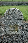
- Bustince-Iriberry Cemetery. There are several of the disc-shaped grave stelae, called Hilarri , which tie in with the tradition of the pre-Christian times. These traditional steles are decorated with Basque crosses or other motifs and were placed on the head of the deceased against the rising sun. The name of the deceased always remains anonymous. In the Bussunarits-Sarrasquette cemetery there are also graves marked with Navarra crosses.
- Hilarri in the Bustince-Iriberry cemetery


Economy and Infrastructure

Agriculture is one of the most important economic factors in the municipality. There is also a sand pit in the municipality where sand and granules are mined. Bustince-Iriberry is located in the AOC zones of the wine-growing region of the Irouléguy , the Ossau-Iraty , a traditionally made cheese made from sheep's milk, as well as the pig breed and the ham "Kintoa".

total = 16
traffic
Bustince-Iriberry is crossed by Route départementale 933 (former Route nationale 133 ).
Web links
- Regional Tourist Office website (French)
- Website of the AOP Ossau-Iraty association (French)
- Filière Porc Basque website (French)
- Bustince and Iriberry on the map by Cassini 1750
Individual evidence
- ↑ Lieux - toponymie: Buztintze-Hiriberri (Garazi) ( fr ) euskaltzaindia . Retrieved March 22, 2017.
- ↑ Ma commune: Bustince-Iriberry ( fr ) Système d'Information sur l'Eau du Bassin Adour Garonne. Retrieved March 22, 2017.
- ↑ a b présentation de la commune de Bustince-Iriberry ( fr ) Ministry of Culture and Communication . Retrieved March 22, 2017.
- ^ A b Paul Raymond: Dictionnaire topographique du département des Basses-Pyrénées ( fr ) In: Dictionnaire topographique de la France . Imprimerie nationale. Pp. 37, 38, 83, 1863. Retrieved March 22, 2017.
- ^ France 1750 ( en ) David Rumsey Map Collection: Cartography Associates. Retrieved March 22, 2017.
- ↑ a b Notice Communale Bustince-Iriberry ( fr ) EHESS . Retrieved March 22, 2017.
- ↑ Populations légales 2006 Commune de Bustince-Iriberry (64155) ( fr ) INSEE . Retrieved March 22, 2017.
- ↑ Populations légales 2014 Commune de Bustince-Iriberry (64155) ( fr ) INSEE . Retrieved March 22, 2017.
- ↑ église paroissiale de l'Assomption-de-la-Bienheureuse-Vierge-Marie ( fr ) Ministry of Culture and Communication . Retrieved March 22, 2017.
- ↑ Conseil régional d'Aquitaine: Eglise Saint-Vincent ( fr ) Visites en Aquitaine. Archived from the original on March 23, 2017. Info: The archive link was inserted automatically and has not yet been checked. Please check the original and archive link according to the instructions and then remove this notice. Retrieved March 22, 2017.
- ↑ ferme Nagila ( fr ) Ministry of Culture and Communication . Retrieved March 22, 2017.
- ↑ ferme Salanoa ( fr ) Ministry of Culture and Communication . Retrieved March 22, 2017.
- ↑ ferme Hegilurrea ( fr ) Ministry of Culture and Communication . Retrieved March 22, 2017.
- ↑ Regional Council of Aquitaine: Cimetière de Bustince-Iriberry ( fr ) Visites en Aquitaine. Archived from the original on March 22, 2017. Info: The archive link was inserted automatically and has not yet been checked. Please check the original and archive link according to the instructions and then remove this notice. Retrieved March 22, 2017.
- ↑ Institut national de l'origine et de la qualité ( fr ) Institut national de l'origine et de la qualité . Archived from the original on February 5, 2017. Info: The archive link was inserted automatically and has not yet been checked. Please check the original and archive link according to the instructions and then remove this notice. Retrieved March 22, 2017.
- ↑ Caractéristiques des établissements en 2014 Commune de Bustince-Iriberry (64155) ( fr ) INSEE . Retrieved on March 22, 2017. ( Page no longer available , search in web archives ) Info: The link was automatically marked as defective. Please check the link according to the instructions and then remove this notice.