Arcangues
|
Arcangues arrangement |
||
|---|---|---|

|
|
|
| region | Nouvelle-Aquitaine | |
| Department | Pyrénées-Atlantiques | |
| Arrondissement | Bayonne | |
| Canton | Ustaritz-Vallées de Nive et Nivelle | |
| Community association | Pays Basque | |
| Coordinates | 43 ° 26 ′ N , 1 ° 31 ′ W | |
| height | 4–140 m | |
| surface | 17.47 km 2 | |
| Residents | 3,160 (January 1, 2017) | |
| Population density | 181 inhabitants / km 2 | |
| Post Code | 64200 | |
| INSEE code | 64038 | |
| Website | http://www.arcangues.fr/ | |
 Arcangues Town Hall |
||
Arcangues ( Basque : Arrangoitze ) is a French municipality with 3160 inhabitants (as of January 1 2017) in the department of Pyrénées-Atlantiques in the region Nouvelle-Aquitaine . Arcangues belongs to the Arrondissement Bayonne and canton Ustaritz-Vallées de Nive et Nivelle (2015: Canton Ustaritz ). The inhabitants are called Arcanguais .
geography
Arcangues is located about seven kilometers south-southwest of Bayonne in the French Basque Country . Arcangues is surrounded by the neighboring communities of Anglet and Biarritz in the north, Bassussarry in the northeast, Ustaritz in the east, Saint-Pée-sur-Nivelle in the south, Ahetze in the southwest and Arbonne in the west.
The A63 autoroute runs through the municipality .
population
| 1962 | 1968 | 1975 | 1982 | 1990 | 1999 | 2006 | 2011 |
|---|---|---|---|---|---|---|---|
| 1,348 | 1,580 | 1,728 | 2,155 | 2,506 | 2,733 | 2,985 | 3,107 |
Culture and sights
- Saint-Jean-Baptiste church, renovations in the 20th century, bell tower from the 16th century, historic monument since 1925
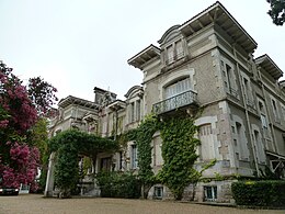
- Arcangues Castle, rebuilt in 1900, Monument historique
- Bosquet Castle, built in 1905
- Villa Berriotz, built in 1929, Monument historique since 2013
Web links
Commons : Arcangues - collection of images, videos and audio files


