
Joke
|
Juxue Jutsi |
||
|---|---|---|
|
||
| region | Nouvelle-Aquitaine | |
| Department | Pyrénées-Atlantiques | |
| Arrondissement | Bayonne | |
| Canton | Pays de Bidache, Amikuze et Ostibarre | |
| Community association | Pays Basque | |
| Coordinates | 43 ° 14 ′ N , 1 ° 3 ′ W | |
| height | 91-648 m | |
| surface | 15.17 km 2 | |
| Residents | 209 (January 1, 2017) | |
| Population density | 14 inhabitants / km 2 | |
| Post Code | 64120 | |
| INSEE code | 64285 | |
 northern entrance to the village |
||

Juxue ( Basque : Jutsi ) is a French municipality with 209 inhabitants (at January 1, 2017) in the department of Pyrénées-Atlantiques in the region Nouvelle-Aquitaine . It belongs to the Bayonne arrondissement and the Pays Basque municipal association . The residents' own name is Jutsiar .
geography
The municipality is located in the historic region of Nieder-Navarra in the French Basque Country , 50 kilometers southeast of Biarritz and about 50 kilometers west of Pau in the foothills of the Pyrenees . The Bidouze , a left tributary of the Adour, flows in a large loop through the north of the municipality . Juxue borders Arhansus in the north, Pagolle in the east, Saint-Just-Ibarre in the south, Bunus in the south-west, Larceveau-Arros-Cibits in the west and Ostabat-Asme in the north-west.

In the south, west and east, the municipal boundaries of Juxue are geographical in nature - they precisely enclose the catchment area of the Bidouze tributary Babatzeko Erreka . In the extreme south lies the 648 m high summit of Mehalçu (Basque: Mehaltzu ), the highest point in the municipality. In addition to the village of Juxue, the municipality includes the districts of Arlania, Arrasia, Beroquia, Goyhenetchia, Landa and Oxarania.
Population development
| year | 1962 | 1968 | 1975 | 1982 | 1990 | 1999 | 2006 | 2017 | |
| Residents | 266 | 243 | 246 | 230 | 221 | 192 | 224 | 209 | |
| Sources: Cassini and INSEE | |||||||||
Attractions
- Saint-Pierre church from 1663
- two fortified houses from the 14th century, another from the 18th century - all as a monument historique reported
- Remains of a prehistoric settlement in the Gaztelu Zahar district
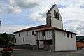
Saint-Pierre church

Altar of the church
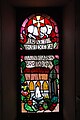
one of the church windows

Frontón Juxue

typical Basque disc-shaped tombstones in Juxue
.jpg)
.jpg)
.jpg)

.jpg)
Economy and Infrastructure
There are 36 farms in the municipality (growing cereals, breeding poultry, cattle, sheep and goats).
The D 933 trunk road from Salies-de-Béarn to Pamplona runs through the north of the municipality of Juxue .