Saint-Martin-d'Arberoue
|
Saint-Martin-d'Arberoue Donamartiri |
||
|---|---|---|

|
|
|
| region | Nouvelle-Aquitaine | |
| Department | Pyrénées-Atlantiques | |
| Arrondissement | Bayonne | |
| Canton | Pays de Bidache, Amikuze et Ostibarre | |
| Community association | Pays Basque | |
| Coordinates | 43 ° 21 ′ N , 1 ° 12 ′ W | |
| height | 96-424 m | |
| surface | 14.69 km 2 | |
| Residents | 315 (January 1, 2017) | |
| Population density | 21 inhabitants / km 2 | |
| Post Code | 64640 | |
| INSEE code | 64489 | |
| Website | www.saintmartindarberoue.fr | |
 Town hall of Saint-Martin-d'Arberoue |
||
Saint-Martin-d'Arberoue is a French municipality with 315 inhabitants (at January 1, 2017) in the department of Pyrénées-Atlantiques in the region Nouvelle-Aquitaine (before 2016: Aquitaine ). The municipality belongs to the Arrondissement of Bayonne and the canton of Pays de Bidache, Amikuze et Ostibarre (until 2015: Canton Hasparren ).
The name of the municipality is Donamartiri in the Basque language . The residents are called accordingly Donamartiritar .
geography
Saint-Martin-d'Arberoue is located about 35 km south-east of Bayonne in the historic Arberoue ( Basque Arberoa ) region in the historic province of Lower Navarra in the French part of the Basque Country .
The highest point in the municipality is the Eltzarruze ( 424 m ).
Saint-Martin-d'Arberoue is surrounded by the neighboring municipalities:
| Isturits | Orègue | |
| Saint-Esteben |

|
Cupid's Succos Méharin |
| Poor charity |
Saint-Martin-d'Arberoue is located in the catchment area of the Adour River .
Tributaries of the Lihoury cross the territory of the municipality,
- the Argazuriko Erreka and
- the Ruisseau l'Arbéroue, namesake of the area, with its tributary,
- the Haltzerreka, which rises in Saint-Martin-d'Arberoue, and its tributary,
- the Othalatzeko Erreka, which also rises in the municipality.
- the Haltzerreka, which rises in Saint-Martin-d'Arberoue, and its tributary,

|

|
|
|
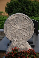
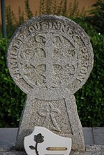
Disc -shaped funerary stelae in the Saint-Martin-d'Arberoue cemetery
|
||
history
In the 19th and 20th centuries, the Isturitz and Oxocelhaya caves were found, which extend over the territories of the municipalities of Isturits and Saint-Martin-d'Arberoue. It is estimated that people have been visiting them since the Moustérien Age over 30,000 years ago.
Around 1249 the village took its shape and was considered the capital of the Arberoue valley. The court of the Bailliage gathered here and ruled on cases in which nobles were involved. John II of Aragon and his wife, Blanka of Navarra , wanted to secure the border with Gascony and in 1435 ennobled 128 houses in the Arberouetal for this purpose. This relieved the families of their obligation to pay the fief , but on the other hand did not give them the right to a seat on the Navarre Estates . In Saint-Martin-d'Arberoue, this affected 23 houses and with a few exceptions all of them in the village. 1657 was the manor of Saint-Martin-d'Arberoue to Baronat raised, the king of Navrarre shelter. With the reorganization of the territories at the beginning of the French Revolution , Saint-Martin-d'Arberoue became the capital of the canton in the district of Saint-Palais for a short time .
Toponyms and mentions of Saint-Martin-d'Arberoue were:
- Sant Martin and Belhoriz (1249),
- Sant Martin de Beloriz (1366),
- Sant-Martin (1513, documents from Pamplona ),
- Saint Martin d'Arberoue (1750, map by Cassini ),
- Saint Martin (1793, Notice Communale ),
- Saint-Martin (1801, Bulletin des Lois ) and
- Saint-Martin-d'Arberoue (1863, Dictionnaire topographique du département des Basses-Pyrénées).
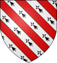
coat of arms
According to Guy Ascarat, heraldist and historian, the coat of arms can be interpreted as follows:
It is the coat of arms of the first lords of Saint-Martin-d'Arberoue. The fur of the ermine was a luxury product in the Middle Ages and wearing was regulated. That is why it is a symbol of the exercise of power. Only sovereigns, members of the royal family, the Pairs of France and certain high-ranking officials were allowed to wear.
Population development
After a peak in the number of inhabitants of around 700 at the beginning of the 19th century, the number fell to around 280 with short recovery phases by the 1980s. As a result, moderate growth has been recorded to this day.
| year | 1962 | 1968 | 1975 | 1982 | 1990 | 1999 | 2006 | 2009 | 2017 |
|---|---|---|---|---|---|---|---|---|---|
| Residents | 373 | 350 | 297 | 284 | 303 | 305 | 293 | 314 | 315 |
Attractions
- Parish church dedicated to Martin of Tours . The date of construction of the previous simple building is not known. It is believed that it existed before the Huguenot Wars at the end of the 16th century and it is possible that the damage in this dispute led to a complete or partial reconstruction of the parish church in the years 1866 and 1867 in the center of the parish at the cemetery . During this work, two were glass windows of the glass painter Pierre-Gustave Dagrand from Bayonne created. The church is equipped with a wooden gallery with rows of benches on two levels, which surrounds the single-nave nave on three sides. A bell gable rises up on the west facade . The long building ends in the east with an apse , under which the sacristy is located in the basement . The white plastered outer walls contrast with the red hollow bricks. This interplay of colors can often be found in sacred buildings as well as in large aristocratic houses in the region. The interior of the church contains a baroque altarpiece from the 17th or 18th century. Its tabernacle is richly decorated with gilded plant motifs and small serpentine columns. Two double columns with capitals form a frame around the reredos, the panel of which shows putti heads in the background . An oculus in the apse with its colored glass window is integrated into the overall work.
- House of Pekoetxea. It has two floors and an attic on a rectangular floor plan. Its roof has three surfaces, one horizontal in the middle and two sloping sides. It shows several peculiarities of the houses of Lower Navarra, its whitewashed outer walls, its gate lined with stones made of sandstone or the wall corners provided with toothed stone , which emphasize the general impression of robustness. Wooden elements such as the beams that hold the roof overhang, door leaves or shutters are painted in the red ox blood colors traditionally used in the Basque Country.
- Isturitz and Oxocelhaya caves. Of the three caves Isturitz, Oxocelhaya and Erberua, only the first two are open to the public from mid-March to mid-November. These two grottos have been classified as Monument historique since October 1st, 1953 . The Erberua cave, on the other hand, is reserved for scientific research.
Economy and Infrastructure
Agriculture, crafts, trade and tourism are the economic factors of the municipality. Agriculture is based on the rearing of sheep and cattle for the production of milk and meat.
Saint-Martin-d'Arberoue is located in the AOC areas of Ossau-Iraty , a traditionally made hard cheese made from sheep's milk, as well as the pig breed and the ham "Kintoa".
The "Agerria" farm in Saint-Martin-d'Arberoue produces, sells and a. Ossau-Iraty and products of the Basque pig "Kintoa". He invites you to taste his products all year round and offers seasonal opportunities to work on lambing, milking, sheep shearing or haymaking.

total = 49
education
The municipality has a public preschool with 22 pupils in the 2017/2018 school year and a private preschool and elementary school "Arberoa Ikastola" with 49 pupils in the 2017/2018 school year. The latter is owned by an association of schools in the Basque Country that teach mainly in the Basque language.
traffic
Saint-Martin-d'Arberoue is crossed by Routes départementales 14 and 251.
Web links
- Atlas du Patrimoine Historique et Culturel with images from Saint-Martin-d'Arberoue (French)
- Saint-Martin-d'Arberoue on the website of the former association of municipalities (French)
- Website of the Isturitz and Oxocelhaya caves (French)
- Website of the "Agerria" farm (French)
- Website of the AOP Ossau-Iraty association (French)
- Filière Porc Basque website (French)
Individual evidence
- ^ Lieux - toponymie: Donamartiri (Arberoa) ( fr ) Royal Academy of the Basque Language . Retrieved December 5, 2017.
- ↑ géoportail - Saint-Martin-d'Arberoue ( fr ) Institut national de l'information geographique et forestière . Retrieved December 5, 2017.
- ↑ Ma commune: Saint-Martin-d'Arberoue ( fr ) Système d'Information sur l'Eau du Bassin Adour Garonne. Retrieved December 5, 2017.
- ↑ a b Grottes d'Isturits, d'Oxocelhaya et d'Erberua ( fr ) visites.aquitaine.fr. Retrieved on December 5, 2017. ( Page no longer available , search in web archives ) Info: The link was automatically marked as defective. Please check the link according to the instructions and then remove this notice.
- ↑ Saint-Martin-d'Arberoue ( fr ) visites.aquitaine.fr. Archived from the original on December 6, 2017. Info: The archive link was inserted automatically and has not yet been checked. Please check the original and archive link according to the instructions and then remove this notice. Retrieved December 5, 2017.
- ↑ a b Guy Ascarat: Armorial Communes Basques ( fr ) Archived from the original on November 16, 2016. Retrieved on December 5, 2017.
- ^ A b Paul Raymond: Dictionnaire topographique du département des Basses-Pyrénées ( fr ) In: Dictionnaire topographique de la France . Imprimerie nationale. P. 150, 1863. Retrieved December 5, 2017.
- ^ Jean-Baptiste Orpustan: Nouvelle toponymie basque ( fr , PDF) p. 61. 2010. Accessed December 5, 2017.
- ^ David Rumsey Historical Map Collection France 1750 ( en ) David Rumsey Map Collection: Cartography Associates. Retrieved December 5, 2017.
- ^ A b Notice Communale Saint-Martin-d'Arberoue ( fr ) EHESS . Retrieved December 5, 2017.
- ↑ Populations légales 2014 Commune de Saint-Martin-d'Arberoue (64489) ( fr ) INSEE . Retrieved December 5, 2017.
- ↑ Église Saint-Martin ( fr ) visites.aquitaine.fr. Archived from the original on January 17, 2018. Info: The archive link was automatically inserted and has not yet been checked. Please check the original and archive link according to the instructions and then remove this notice. Retrieved December 5, 2017.
- ↑ église paroissiale Saint-Martin ( fr ) Ministry of Culture and Communication . Retrieved December 5, 2017.
- ↑ Retable de l'église Saint-Martin ( fr ) visites.aquitaine.fr. Archived from the original on January 17, 2018. Info: The archive link was automatically inserted and has not yet been checked. Please check the original and archive link according to the instructions and then remove this notice. Retrieved December 5, 2017.
- ↑ Maison Pekoetxea ( fr ) visites.aquitaine.fr. Retrieved on December 5, 2017. ( Page no longer available , search in web archives ) Info: The link was automatically marked as defective. Please check the link according to the instructions and then remove this notice.
- ↑ Site archéologique des grottes d'Isturits, d'Oxocelhaya et d'Erberua (également sur commune de Saint-Martin-d'Arberoue) ( fr ) Ministry of Culture and Communication . Retrieved December 5, 2017.
- ↑ Visites et tarifs ( fr ) Les Grottes d'Isturitz. Retrieved December 5, 2017.
- ↑ Saint-Martin-d'Arberoue / Donamartiri ( fr ) municipality of Saint-Martin-d'Arberoue. Retrieved December 5, 2017.
- ↑ Institut national de l'origine et de la qualité: Rechercher un produit ( fr ) Institut national de l'origine et de la qualité . Retrieved December 5, 2017.
- ↑ Caractéristiques des établissements en 2015 Commune de Saint-Martin-d'Arberoue (64489) ( fr ) INSEE . Retrieved December 5, 2017.
- ^ Pyrénées-Atlantiques (64), Saint-Martin-d'Arberoue, écoles ( fr ) National Ministry of Education. Retrieved December 5, 2017.


