
Uhart-Cize
|
Uhart-Cize Uharte Garazi |
||
|---|---|---|
.svg)
|
|
|
| region | Nouvelle-Aquitaine | |
| Department | Pyrénées-Atlantiques | |
| Arrondissement | Bayonne | |
| Canton | Montagne Basque | |
| Community association | Pays Basque | |
| Coordinates | 43 ° 10 ′ N , 1 ° 15 ′ W | |
| height | 149–1,064 m | |
| surface | 11.66 km 2 | |
| Residents | 806 (January 1, 2017) | |
| Population density | 69 inhabitants / km 2 | |
| Post Code | 64220 | |
| INSEE code | 64538 | |
| Website | www.uhart-cize.fr | |
 Parish Church of Saint Martin |
||

Uhart-Cize is a French municipality with 806 inhabitants (at January 1, 2017) in the department of Pyrénées-Atlantiques in the region Nouvelle-Aquitaine (before 2016: Aquitaine ). The municipality belongs to the Arrondissement of Bayonne and the canton of Montagne Basque (until 2015: canton of Saint-Jean-Pied-de-Port ).
The name in the Basque language is Uharte Garazi . The inhabitants are called accordingly Uhartear or Uhartegaraztar . It is a derivative of the Basque ur arte ( German between the waters ). The name refers to the geographical location at the confluence of the Nive (Nive de Béhérobie) with the Nive d'Arnéguy . The addition Cize is used to distinguish it from the name of the community Uhart-Mixe .
geography
Uhart-Cize is located approx. 50 km southeast of Bayonne and in the immediate vicinity of Saint-Jean-Pied-de-Port in the historic Pays de Cize ( Basque Garazi ) of the historic province of Lower Navarra in the French part of the Basque Country .
Uhart-Cize is surrounded by the neighboring communities:
| Ascarat | Ispoure | |
| Let |
.svg)
|
Saint-Jean-Pied-de-Port Saint-Michel |
| Arnéguy |
In addition to the main settlement, the community also includes the hamlets Eskanda, Gaztelu-mendi, Gezaine, Kataritze, Pentxeto and Zihe.
Uhart-Cize is located in the catchment area of the Adour River .
The municipality is irrigated by the Nive, a tributary of the Adour, here called La Nive de Béhérobie , and its tributaries,
- the Nive d'Arnéguy and its tributaries,
- the Ruisseau de Pagola, also called Pagolako Erreka ,
- the Ruisseau de Landarréta, also called Alameiko Erreka ,
- the Ruisseau de Hontalatzé, also called Hontalatzeko Erreka and
- the Ruisseau de Sourits, also known as Zuritzeko Erreka .

history
Uhart-Cize was first mentioned in the 12th century in the copial book of the Diocese of Bayonne . In the Middle Ages , the village was the most important of the Pays de Cize with around 40 houses, half of which were noble houses. Uhart-Cize and the village of Ugange were only separated by a ford across the Nive. They were administered together, although the parishes remained separate. Ugange was incorporated into Saint-Jean-Pied-de-Port in the 14th or 15th century, Uhart kept his autonomy. The parish church, which dates from the 14th century, maintained lands together with the monastery of Roncesvalles , which suggests that Uhart-Cize could have been a stop on one of the pilgrimage routes to Santiago de Compostela . The monastery received a quarter of the tithe from Uhart.
Toponyms and mentions of Uhart-Cize were:
- Uhart (1193, copy book of the Diocese of Bayonne, sheet 19),
- Huart (1264),
- Uhart (1366 and 1413),
- Uhart (1513, documents from Pamplona),
- Uharte (1621, after Martin de Viscay),
- Uhart (1750, 1793 and 1801, map from Cassini , Notice Communale or Bulletin des lois ) and
- Uhart-Cize (1863, Dictionnaire topographique du département des Basses-Pyrénées).
coat of arms
The municipality has had the coat of arms since 2004 and can be interpreted as follows according to Guy Ascarat, heraldist and historian.
The two wavy bars on the field at the top left symbolize the rivers Nive and Nive d'Arnéguy, which flow together at Uhart-Cize. In the free quarter at the top left the symbol of a church reminds of the Gothic parish church from the 14th century. The red bars on the top right and the kettle below are borrowed from the coat of arms of the Hegoburu family from Uhart-Cize. For the Celts, the apple tree was the tree of life with the same value as the oak. The apple is the fruit of skill, the kettle a symbol of abundance. The symbols apple tree, apple and cauldron have been used extensively by "initiates", including the Hegoburu family, for example. The four scallops indicate the destination of the whole Pays de Cize in connection with one of the pilgrimage routes to Santiago de Compostela .
Population development
After an initial peak of the population of 700 in the middle of the 19th century, the number fell to around 470 during brief recovery phases until the 1950s, when a temporarily strong growth trend set in, which has reached new highs and continues today.
| year | 1962 | 1968 | 1975 | 1982 | 1990 | 1999 | 2006 | 2009 | 2017 |
|---|---|---|---|---|---|---|---|---|---|
| Residents | 477 | 498 | 518 | 563 | 658 | 599 | 613 | 669 | 806 |

Attractions
Parish church

The church, consecrated to Martin von Tours , was built in the Gothic steeple in the 14th or 15th century. During the Huguenot Wars it was partially destroyed by Protestant troops led by Gabriel de Lorges , Count of Montgomery, only the choir was spared from being demolished. The church was restored 1650 and 1767 as the corresponding years on the sill of a window or on the lintel of the entrance to Sakristei occupy. However, it retained Gothic elements such as the polygonal apse , the nave with a nave , a wall grave and the entrance portal . This is designed with four archivolts in the shape of a pointed arch . Each of the vaults of the robe rests on narrow pillars . New restorations took place during the 19th and 20th centuries. In the late 19th century, a neo-Gothic style burial chapel was built between two buttresses on the outer wall of the apse. It contains the graves of the Reculusa and Apesteguy families. The apse is decorated with corbels below the edges of the polygonal roof surfaces. Four of the original five outer walls have been preserved today, five of the six buttresses. The sacristy was added on the north side for this purpose. Pointed arched windows on each wall of the apse, designed as tracery , illuminate the choir. They have two tracks that run upwards in three passes with an oculus in the arc field. Each buttress has a cantilever on which statues of saints could have stood. A two-flight external stone staircase on the south side of the building leads to the two-level gallery in the western part of the interior, which dates from the 18th century. The nave is equipped with a false four-part ribbed vault , the choir with a six-part ribbed vault. The church has been classified as a Monument historique since April 18, 2014 . The Uhart-Cize cemetery is characterized by its numerous crosses in the style of Lower Navarra, which gradually replaced the disc-shaped grave stelae from the 18th century .
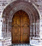
Entrance portal

Cemetery with apse of the parish church
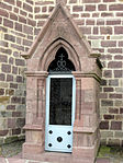
Burial chapel at the apse

Staircase as access to the gallery

Figure of a saint in a niche in the entrance porch


town hall
It is now located in a building of a former farm mentioned in the Navarre archives before 1350. In small communities, a village house is often converted into a town hall in order to avoid expensive new construction. The current building was erected in 1618, as evidenced by the year on a plaque above the entrance. The former farmhouse was a three-part building with an eskaratz in the middle, a central entrance area, living rooms on the first floor, a stable in the rear area and a hayloft in the attic. As a result, the farmhouse became a rectory and was named Apezetxea , followed by today's town hall with rental apartments on the first floor. Small restorations took place in the 19th century, more extensive work in the 20th century. The slightly inclined gable roof is covered with hollow tiles. The windows are framed with limestone , the arched entrance door, the former gateway, with massive wedge stones. The middle window on the first floor has a protruding, beaded window sill and its lintel is embellished with geometric motifs. The two outer windows on the first floor are distinguished by tooth-shaped ornaments under their sills. The facade of the gable is interrupted by four small windows. The arches supporting the roof rest on corbels, with a human figure engraved in the middle. The facade on the left shows two windows with protruding, corrugated outer window sills and two arched doors, one of which led to the former stable.
Former Collège Dujakenea
It got its name from Dionisio Dujac, canon of Uhart-Cize, who had it built in 1731 to establish the first college in Lower Navarre. It got its present appearance mainly after renovations in the 18th or 19th century, when the former hipped roof was replaced by an asymmetrical gable roof. The house has cross-frame and twin windows with protruding, corrugated window sills, which are believed to date from the early 18th century. The house is accessed through a simple, rectangular door under the right cross-window on the first floor. Some earlier windows were bricked up, especially in the left front area of the ground floor, but also a door in the rear area. Small restorations took place in the course of the 19th century, mainly the construction of a room in an annex on the left. The building, registered as a national cultural asset, is now a single-family home and is not open to the public.
House, called Villa Harriet
It was built in the 1930s in the Neo-Basque style with influences from Normandy . This can be seen from the wooden beams, massive arches and the roof with half-hips. The arched windows and doors, the compact structure and the roof with elongated surfaces underline the neo-Basque style. Fluted pilasters on the entrance porch and on the earlier pergola are examples of classic elements. The villa consists of two wings that are arranged in a T-shape. The protruding part with two floors and an attic is built higher. The tract, which is perpendicular to it, has only two floors.

|

|
|
|
Arthur Wellesley, 1st Duke of Wellington
|
Nicolas Jean-de-Dieu Soult
|
Redoute Kurutchamendy
It was created in 1813 by the French Maréchal Nicolas Jean-de-Dieu Soult as a defense against the advancing Allied army under the command of Arthur Wellesleys , later the Duke of Wellington . It has been classified as a Monument historique since December 31, 1992.
Economy and Infrastructure

Uhart-Cize is located in the AOC zones of Ossau-Iraty , a traditionally produced semi-hard cheese made from sheep's milk, as well as the pig breed and the ham "Kintoa".

total = 102
sport and freetime
- The GR 65 long-distance hiking trail from Geneva to Roncesvalles runs on the border with Saint-Jean-Pied-de-Port. It follows the Via Podiensis , one of the four historic St. James' paths.
- The long-distance hiking trail GR 10 from Hendaye on the Atlantic to Banyuls-sur-Mer on the Mediterranean leads through the center of the municipality.
- A very easy circular route with a length of 4 km and a difference in altitude of 50 m leads from the school in the district of Mayorga of Saint-Jean-Pied-de-Port around the Kurutxamendi hill in the area of the municipality of Uhart-Cize. It runs along part of the Camino de Santiago and past the Kurutchamendy Redoubt.
traffic
Uhart-Cize can be reached via Routes départementales 15, 381, 403, 428, 918 (former Route nationale 132 ) and 933 (former Route nationale 133 ) and can be reached via a line from the Transports 64 bus network via Saint-Jean-Pied-de- Port connected with other communes of the department.
Personalities
- Joseph Matenot, called Matenotte or La victoire , born on November 24, 1750, died on June 7, 1794 in Saint-Étienne-de-Baïgorry , was a brigadier general in the Revolutionary Army . From 1770 to 1777 he served in an infantry regiment of the royal army, where he earned his nickname La victoire . On October 15, 1777 he married Jeanne Fonrouge and lived in Uhart-Cize in the Chimalenia house, where he worked as a master tailor and had eight children. On August 3, 1789, he joined the National Guard at Saint-Jean-Pied-de-Port. He was fatally wounded at the Battle of Berderitz in the Baztan Valley on June 3, 1794.
- Michel Albert Jean Joseph Ybarnégaray, born on October 16, 1883 in Uhart-Cize, died on April 25, 1956 in Paris , was a French politician. Through his participation in the First World War he earned the rank of Knight of the Legion of Honor . As a trained lawyer, he founded the French and International Pelota Association in 1929. He was Mayor of Uhart-Cize and Member of Parliament for Mauléon from 1914 to 1942. He was Ministre d'État in the cabinet of Paul Reynaud in 1940 and Minister in the Philippe Pétain's government . On July 10, 1940, he voted for the Enabling Act that ended the Third French Republic . Because of his participation in the Vichy government, he was sentenced to so-called "national harm" after the end of World War II . The penalty, the loss of his civil rights, was suspended for his help in crossing persecuted people across the Pyrenees . He died in Paris but was buried in the Uhart-Cize cemetery.
- Pierre Camou, born on August 18, 1945 in Uhart-Cize, was President of the Fédération Française de Rugby from 2008 to 2016 .
Web links
- Atlas du Patrimoine Historique et Culturel with images from Uhart-Cize (French)
- Information about Uhart-Cize on the website of the association of municipalities (French)
- "Transports 64" bus from the department (French)
- Website of the AOP Ossau-Iraty association (French)
- Filière Porc Basque website (French)
Individual evidence
- ↑ Lieux - toponymie Uharte Garazi (Garazi) ( fr ) euskaltzaindia . Retrieved December 29, 2017.
- ↑ a b Uhart-Cize ( fr ) visites.aquitaine.fr. Archived from the original on December 29, 2017. Info: The archive link was inserted automatically and has not yet been checked. Please check the original and archive link according to the instructions and then remove this notice. Retrieved December 29, 2017.
- ↑ a b Jean-Baptiste Orpustan: Nouvelle toponymie basque ( fr , PDF) p. 84. 2010. Retrieved on December 29, 2017.
- ^ A b Paul Raymond: Dictionnaire topographique du département des Basses-Pyrénées ( fr ) In: Dictionnaire topographique de la France . Imprimerie nationale. P. 170, 1863. Retrieved December 29, 2017.
- ↑ Ma commune: Uhart-Cize ( fr ) Système d'Information sur l'Eau du Bassin Adour Garonne. Retrieved December 29, 2017.
- ↑ a b Guy Ascarat: Armorial Communes Basques ( fr ) Archived from the original on March 25, 2016. Retrieved on December 29, 2017.
- ^ David Rumsey Historical Map Collection France 1750 ( en ) David Rumsey Map Collection: Cartography Associates. Retrieved December 29, 2017.
- ↑ a b Notice Communale Uhart-Cize ( fr ) EHESS . Retrieved December 29, 2017.
- ↑ Populations légales 2014 Commune de Uhart-Cize (64538) ( fr ) INSEE . Retrieved December 29, 2017.
- ↑ Église Sainte Marie ( fr ) visites.aquitaine.fr. Archived from the original on December 29, 2017. Info: The archive link was inserted automatically and has not yet been checked. Please check the original and archive link according to the instructions and then remove this notice. Retrieved December 29, 2017.
- ↑ Portail de l'église Sainte Marie ( fr ) visites.aquitaine.fr. Archived from the original on December 30, 2017. Info: The archive link was automatically inserted and has not yet been checked. Please check the original and archive link according to the instructions and then remove this notice. Retrieved December 29, 2017.
- ^ Eglise Notre-Dame de l'Assomption ( fr ) Ministry of Culture and Communication . Retrieved December 29, 2017.
- ↑ église paroissiale Saint-Martin ( fr ) Ministry of Culture and Communication . Retrieved December 29, 2017.
- ↑ Cimetière à croix bas-navarrais d'Uhart-Cize ( fr ) visites.aquitaine.fr. Archived from the original on December 29, 2017. Info: The archive link was inserted automatically and has not yet been checked. Please check the original and archive link according to the instructions and then remove this notice. Retrieved December 29, 2017.
- ↑ Mairie d'Uhart-Cize ( fr ) visites.aquitaine.fr. Archived from the original on December 29, 2017. Info: The archive link was inserted automatically and has not yet been checked. Please check the original and archive link according to the instructions and then remove this notice. Retrieved December 29, 2017.
- ↑ ferme, puis presbytère, actuellement mairie ( fr ) Ministry of Culture and Communication . Retrieved December 29, 2017.
- ↑ Ancien collège Dujakenea ( fr ) visites.aquitaine.fr. Archived from the original on December 29, 2017. Info: The archive link was inserted automatically and has not yet been checked. Please check the original and archive link according to the instructions and then remove this notice. Retrieved December 29, 2017.
- ↑ collège Dujakenea, actuellement maison ( fr ) Ministry of Culture and Communication . Retrieved December 29, 2017.
- ↑ Maison dite Villa Harriet ( fr ) visites.aquitaine.fr. Archived from the original on December 30, 2017. Info: The archive link was automatically inserted and has not yet been checked. Please check the original and archive link according to the instructions and then remove this notice. Retrieved December 29, 2017.
- ↑ maison appelée villa Harriet ( fr ) Ministry of Culture and Communication . Retrieved December 29, 2017.
- ↑ Redoute de Kurutchamendy ( fr ) Ministry of Culture and Communication . Retrieved December 29, 2017.
- ↑ Institut national de l'origine et de la qualité: Rechercher un produit ( fr ) Institut national de l'origine et de la qualité . Retrieved December 29, 2017.
- ↑ Caractéristiques des établissements en 2015 Commune de Uhart-Cize (64538) ( fr ) INSEE . Retrieved December 29, 2017.
- ↑ GR® 65, le chemin de Compostelle via le Puy ( fr ) Fédération française de la randonnée pédestre . Retrieved December 29, 2017.
- ↑ GR®10: la traversée des Pyrénées ( fr ) Comité Régional de la Randonnée Pédestre Midi-Pyrénées. Retrieved December 29, 2017.
- ↑ Kurutxamendi La montagne de la croix ( fr , PDF) Office de tourisme de Saint-Jean-Pied-de-Port / Saint-Étienne-de-Baïgorry. Retrieved December 29, 2017.
- ↑ Jean Ybarnégaray ( fr ) visites.aquitaine.fr. Archived from the original on December 29, 2017. Info: The archive link was inserted automatically and has not yet been checked. Please check the original and archive link according to the instructions and then remove this notice. Retrieved December 29, 2017.