Sangzor
|
Sangzor Сангзор, Санза́р, Guralashsoy / Гуралашсой, Qili / Қили |
||
|
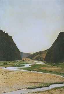
The Sangzor leaving the mountains at the Tamerlaner Tor |
||
| Data | ||
| location | Jizzax ( Uzbekistan ) | |
| River system | Sangzor | |
| source |
Turkestan chain 39 ° 34 ′ 51 ″ N , 68 ° 15 ′ 49 ″ E |
|
| Source height | approx. 3400 m | |
| muzzle | in the lake Tuzkon coordinates: 40 ° 30 '57 " N , 67 ° 37' 26" O 40 ° 30 '57 " N , 67 ° 37' 26" O |
|
| Mouth height | approx. 240 m | |
| Height difference | approx. 3160 m | |
| Bottom slope | approx. 16 ‰ | |
| length | 198 km | |
| Catchment area | 2530 km² | |
| Outflow location: 158 km above the mouth |
MQ |
2.12 m³ / s |
| Big cities | Jizzax | |
| Small towns | Gallaorol | |
The Sangzor (Сангзор; Russian Санза́р Sansar ; in the upper reaches Guralashsoy / Гуралашсой; in the lower reaches Qili / Қили) is a river in Uzbekistan ( Central Asia ).
The Sangzor rises as Guralashsoy on the northern flank of the western ridge of the Turkestan chain . Its headwaters are in the Zomin National Park . The Sangzor initially flows in a westerly direction through the mountains. At the city of G'allaorol it turns first to the north and shortly afterwards to the east. It flows through the city of Jizzax and reaches the lowlands of the Golodnaya Steppe , where countless irrigation channels branch off. The actual course of the river flows into Lake Tuzkon or Lake Aydar about 40 km northwest of Jizzax .
The Sangzor has a length of 198 km. Its catchment area (above the irrigation fan) covers 2530 km². The river is mainly fed by the snowmelt . Between the end of March and the beginning of July it leads to regular floods . The mean discharge 158 km above the mouth is 2.12 m³ / s. Above the irrigation fan it is only 4 l / s. Most of the water from the Sangzor is diverted for irrigation purposes.

