Towada (volcano)
| Towada | ||
|---|---|---|
| height | 1159 m | |
| location | Border of Aomori and Akita Prefectures , Japan | |
| Coordinates | 40 ° 27 '32 " N , 140 ° 54' 43" E | |
|
|
||
| Type | Caldera | |
| rock | Basalt , andesite , dacite , rhyolite | |
| Age of the rock | Gelasian to Holocene | |
| Last eruption | 915 | |
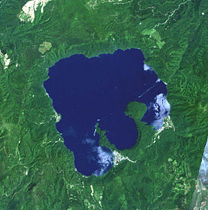
The Towada ( Japanese : 十 和田 火山) is a caldera on the Japanese island of Honshū . It lies on the border of the Aomori and Akita prefectures in Towada-Hachimantai National Park .
The caldera with a diameter of around eleven kilometers was formed in six major volcanic eruptions 40,000 to 13,000 years ago. Lake Towada was formed in the caldera with a water level of 400 meters above sea level. The walls of the caldera reach a height of about 1000 meters; the highest peak is 1159 meters high.
In south-southeast of Towada caldera which was created stratovolcano Ninokura , which was destroyed by subsequent explosive eruptions. In its place is the Nakanoumi caldera with a diameter of about two kilometers. Its southwest and northeast edge currently forms two peninsulas in Lake Towada. During the last major eruption in 915, the Ogura lava dome bulged on the northeastern peninsula . During the eruptions of magnitude five on the volcanic explosion index (VEI), pyroclastic currents formed ; around 6.5 cubic kilometers of tephra were extracted.
The volcano can be reached from Aomori by public bus.
Web links
- Geological history of the volcano (Japanese)
- Towada in the Global Volcanism Program of the Smithsonian Institution (English)
- Towada in the Japanese Volcanoes Quaternary database (English and Japanese)
- Page with information and pictures about the volcano

