
Treherz
|
Treherz
municipality Aitrach
Coordinates: 47 ° 56 ′ 6 ″ N , 10 ° 2 ′ 48 ″ E
|
|
|---|---|
| Height : | 684 m above sea level NN |
| Residents : | 35 (2012) |
| Postal code : | 88319 |
| Area code : | 07565 |
Treherz is located in the middle between Bad Wurzach and Memmingen on the southern edge of the Holzstocks and is a district of Aitrach in the Ravensburg district .
description

The place name cannot be derived from three hearts. Originally it was probably owned by a man named Dreher. So Dreherz, that was written around 1500 Threerz , since 1900 one has written Treherz .
In the middle of the 16th century, the head chef Jakob von Waldburg-Zeil bought the former monastery property and built a tenth-free camera property on it . He designated the main building as his hunting lodge . Because the way to Aitrach or Hauerz was too far, the construction of a parish church was planned in 1798 . First in Treherz the old chapel and the pilgrimage chapel St. Johann im Wald from 1607 were demolished and the material used to build a parish church in the then new classical style. In 1801 the new church of John the Baptist was consecrated.
Part of the community
Ecclesiastically, Treherz belongs to the Aitrachtal pastoral care unit in the Allgäu-Oberschwaben dean's office. Treherz has a number of historic buildings. Only a few buildings are of modern origin, such as the village community center and a small building area on Katzenbuckel. The suburb has a music association founded in 1899.
Events
- Christmas Market
societies
- Musikverein Treherz eV
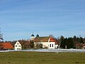
Treherz from the west

Church of John the Baptist

John the Baptist, inside

The camera property

goal

Village community center Treherz


Web links
Baniswald | Breitenbach | Degenreute | Ferthofen | Häberlings | Long wall | Marstetten | Mooshausen | Oberhausen | Ochsensteig | Pfänders | Pfändershof | Rank | Ried | Vineyards | Rotengrund | Sankt Johann | Schmiddis | Schnaggenberg | Sigglis | Stibi | Treherz | Vogelherd | Forest | Watzeney