
Wooden sticks
| Wooden sticks | |||
|---|---|---|---|
n.jpg) |
|||
| surface | 381.9 km² | ||
| Systematics according to | Handbook of the natural spatial structure of Germany | ||
| Greater region 1st order | 02–06 → Alpine foothills |
||
| Greater region 2nd order | 04–06 → Southern Alpine Foreland |
||
| Greater region 3rd order | 04 → Donau-Iller-Lech-Platte |
||
| 4th order region (main unit) |
043 → wooden sticks |
||
| Natural area characteristics | |||
| Landscape type | Terrace and slab landscape | ||
| Highest peak | Edge elevations at the seam to the Riß-Aitrach-Platten ( 700 m ) | ||
| Geographical location | |||
| Coordinates | 48 ° 7 '52 " N , 10 ° 1' 0.5" E | ||
|
|||
| state | Baden-Württemberg | ||

The wood sticks are elongated, wooded in north-south direction, up to about 700 m above sea level. NN high and 381.9 square kilometers, Riedel-like (high) terrace landscape of the Danube-Iller-Lech-Platte in the Alpine foothills . They extend not far south-west of Ulm in the Alb-Danube district and in the Biberach district in Upper Swabia and tower over the valley floors by around 75 m.
geography
Geographical location
The wood sticks in the broader sense extend as a flat hill country between the rivers Iller in the east and Riss in the west; to the south they protrude until just before the Aitrach , to the north they flatten towards the Danube . They mainly consist of the catchment areas of the upper and middle reaches of the north and north-west flowing rivers Weihung (from the source south of Wains to Staig- Steinberg), Rot ( Haslach from the source via Haslach to the confluence in Rot an der Rot , Rot further via Schwendi to Burgrieden-Rot ) and Rottum (from south of Ochsenhausen to Mietingen ); to the southwest they end with the valley of the Dürnach near Maselheim .
Usually only the wooden sticks in the narrower sense are drawn as such on maps, see below .
Natural structure
According to the structure of the handbook of the natural spatial structure of Germany and the refinements of the individual sheets Ulm and Lindau , the wooden sticks are structured as follows:
-
043 wooden sticks
- 043.0 (0) Wooden sticks in the narrower sense
- 043.1 red plates
- 043.10 Lower terraces of the Rot-Platten
- 043.11 Erlenmoser plate
- 043.12 Heggbacher plate
- 043.13 Terraces and hills on the Dürnach
- 043.14 Haslach plates
- 043.15 Erolzheim hill country

The wooden sticks in the narrower sense are the north-north- eastern part on both sides of the consecration around Wain . They reach west to the valley of the Rot and south to the immediate west of Erolzheim .
To the west, the lower terraces of the Rot-Platten adjoin the valleys of Rottum and Rot in a horseshoe shape from the north around the 30 m higher Erlenmoser Platte with Erlenmoos and Ochsenhausen oaks.
West of Rottum the closing Heggbacher plate to Heggbach on that west to the terraces and hills on the Dürnach in Maselheim encounters.
To the south of the wooden sticks in the narrower sense , the Erolzheimer hill country to the west of Erolzheim and Berkheim leads in a narrow riedel to the Haslach-Platten on both sides of the Haslach around Haslach .
To the northwest, the landscape flattens towards the (eastern) hill country of the Untere Riss (042.2) near Laupheim , while it rises to the southeast to the old moraine ( old moraine area between Riss and Rottum . 041.2) of the Riss-Aitrach plates (041) ( Wachbühl : 791 m). To the east, the drop to the Lower Illertal (044) is clear with a conspicuously north-south-oriented dividing line.
Surveys
In the southern part of the wooden sticks near Aitrach, the altitude from the north ranges from around 500 m above sea level. NN near Illerkirchberg gradually rising to the south within the framework of unnamed elevations and hills up to the 700 meter contour line .
The named elevations of the wooden sticks also include - sorted by height in meters (m) above sea level (NN):
- Round head ( 631.3 m ), 1.3 km west-northwest of Erolzheim ; with transmission tower and water tank
- Roter Berg ( 629.2 m ), 1 km south-southwest of Erolzheim
- Frohberg ( Kapellenberg ; approx. 629 m ), directly south-southwest of Erolzheim; with Froberg chapel and water tank
- Gehrn ( Gern ; 621.7 m ), 2 km north-north-west of Berkheim
- Banberg ( 618.5 m ), directly west of Tannheim - Haldau
- Grafenberg ( 618.3 m ), 2.5 km west-southwest of Kirchberg
- Totenkopf ( 615.6 m ), 1 km east-southeast of Tannheim- Krimmel ; with nearby Keltenschanze
- Weiherkopf ( 600.4 m ), 1.3 km north-northwest of Erolzheim
- Schlossberg ( 568.4 m ), 1.2 km southeast of Gutenzell-Hürbel - Niedernzell ; with Burgstall Gutenzell Location: 48 ° 7 '52 " N , 10 ° 1' 0.5" E
- Weissenberg ( 550.9 m ) between iller and dedication at Illerrieden range: 48 ° 15 '40.7 " N , 10 ° 2' 29.6" O
Forest use
The proportion of forest in the logs is one of the highest in the region. The area around Illerkirchberg was last cleared in the 18th century.
Around 1882 the Kingdom of Württemberg required the inhabitants of the wooden sticks to cut the wood and deliver it to the kingdom. Despite the wooded valleys, the area was largely populated by poor people. In order to defy the king, the forest owners cut down the trees four feet above the floor , thereby fulfilling the king's request and allowing the residents to use the lower, more valuable part of the trunk for themselves.
gallery

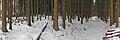
The wooden sticks near Wain in the Biberach district

Panoramic view SW of Dietenheim

The wooden sticks in the valley of consecration, north of the hamlet of Grubach, municipality of Schwendi
The wooden sticks, south of Kirchberg an der Iller

The consecration is a small river that flows through the wooden sticks.

The Tannschorrenweiher on the Haslach-Platten between Haslach and Tannheim
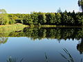
Tannschorrenweiher


Individual evidence
- ↑ a b map services ( memento of the original from December 19, 2012 in the Internet Archive ) Info: The archive link was inserted automatically and has not yet been checked. Please check the original and archive link according to the instructions and then remove this notice. of the BfN
- ^ A b Emil Meynen , Josef Schmithüsen : Handbook of the natural spatial structure of Germany . Federal Institute for Regional Studies, Remagen / Bad Godesberg 1953–1962 (9 deliveries in 8 books, updated map 1: 1,000,000 with main units 1960).
-
↑ a b Various authors: Geographical land survey: The natural space units in single sheets 1: 200,000 . Federal Institute for Regional Studies, Bad Godesberg 1952–1994. → Online maps
- Sheet 179: Ulm (Hans Graul 1952; 39 pages)
- Sheet 187/193: Lindau / Oberstdorf (Hansjörg Dongus 1991; 94 pages)
- ↑ On Blatt Ulm, this natural area is misleadingly referred to as Die Rot Platten .
- ^ Message from the Wiblingen Monastery, today in the Rottenburg Diösesan archive
Web links
- Natural area profile wooden sticks (043) - LUBW (PDF; 6.7 MB; notes )
- BfN - Landscape profile wood sticks - BfN (much less detailed; slightly different demarcation, therefore slightly increased area)