
Trift Glacier (Gadmen)

The Trift Glacier is a valley glacier near Gadmen in the far east of the Canton of Bern , in the central Alps of Switzerland . In 1973 it was about 5.75 km long, up to 3 km in the upper part, but hardly more than 500 m wide in the tongue area. At that time it covered an area of approximately 16.55 km² with its side glaciers.
The Trift Glacier arises from several firn basins on the northern flank of the Winterberg massif. He takes his starting point on the northern slope of the glaciated Tieralplistock at 3300 m above sea level. M. It flows north into a vast arena 3 km in diameter, on the west by Diechterhorn ( 3389 m above sea level. M. ) and to the east by the White Nollen ( 3398 m above sea level. M. limited). Over the firn-covered pass ( 3,081 m above sea level ) of the Untere Triftlücke the glacier has a connection to the south with the Rhone glacier . Further inflows, the Triftgletscher from the drift bag , a Kar north of the White Nollen, the vertical on three sides by almost 300 m high rock walls surrounded, and the rear Tierberg from Gwächtenhorn ( 3215 m above sea level. M. ) and the Steinhüshorn ( 3121 m above sea level ). On the Upper Sack , the glacier plunges steeply into the depths over a 400 m high rock face (with a gradient of around 60%). The Trift Glacier flowed below this steep point in 2004 at around 1660 m above sea level. M. into a lake above the Windegg rock ledge. The Triftwasser flows from the lake through a gorge in the rock barrier, a side stream of the Gadmerwasser, which flows into the Aare at Innertkirchen . In 2016 the glacier retreated over this rock barrier, below there is only a dead ice field, the rest of the former glacier tongue.
In the high stage of the Little Ice Age around the middle of the 19th century, the Trift Glacier overlapped this rock bar, extending over 2 km further down the valley and ending at 1,400 m above sea level. M. The basin in which the lake lies today was filled with a large mass of ice until well into the 20th century. In the 1990s, smaller meltwater pools began to form on the glacier tongue directly behind the rock barrier, which gradually enlarged. The hot summer of 2003 hit the glacier particularly hard. The lake quickly became larger and the glacier tongue literally sank into the meltwater lake or dissolved in it, which led to a glacier retreat of over 136 m within a year. Since 1861 the glacier has retreated a total of 2,771 m.
The Trift Glacier was first crossed lengthways in 1839. A group of three with Gottlieb Studer started in the Gadmertal and reached the Grimsel pass via the Rhone glacier the next day .
At 2520 m above sea level M. on the western slope of the Hinterer Tierberg is the Trifthütte of the Swiss Alpine Club SAC. Until 2004 it could only be reached by crossing the Trift Glacier. The path used to lead over the glacier tongue where the lake is today. At the turn of the millennium, the hut could only be reached by experienced alpine hikers. In order to make the accommodation accessible to a larger hiking audience again, the Trift Bridge was built over the Trift water at the Felsriegel in 2004 . In 2009 this was replaced by a new design. It is one of the longest and highest rope bridges in Europe. One of the hut ascent variants to the Windegghütte leads past the rope bridge without having to cross it.
Kraftwerke Oberhasli AG (KWO) are planning to build a reservoir below the Trift Glacier . It would be the first new reservoir to be built in Switzerland in thirty years. The project is justified with the energy transition and climate protection. While large environmental groups have given their consent, an opposing committee has formed.
Picture gallery
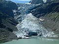
Trift glacier in summer 2006
Trift Glacier in September 2006

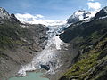
Trift glacier in summer 2007

Old Trift Bridge over the Trift water

Trift glacier in winter 2014


Web links
- A short historical outline of the Trift Glacier with historical photos on windegghuette.ch
- Images and QTVR panoramas of the Trift Glacier on Glaciers online
- Comparative pictures of the retreat of the Trift Glacier 1948-2002-2006
- Construction of the bridge over the Trift Gorge
- Swiss glacier network
swell
- ^ Research institute for hydraulic engineering, hydrology and glaciology (VAW) of the ETH Zurich (ed.): Changes in length of the Trift glacier (Gadmen). In: Swiss Glacier Measurement Network. ( ethz.ch , also as PDF ).
- ↑ Webcam Swiss glacier
- ↑ Overcoming a great fear. (No longer available online.) Archived from the original on May 26, 2015 ; accessed on May 27, 2015 . Info: The archive link was inserted automatically and has not yet been checked. Please check the original and archive link according to the instructions and then remove this notice.
- ↑ Trift reservoir and power plant on the KWO website, accessed on August 2, 2019
- ↑ Objection to the reservoir project on the Trift Glacier. In: NZZ , February 7, 2018
- ↑ Reservoir Project - Against the Destruction of the Trift on the Trift Committee's website, accessed on August 2, 2019
Coordinates: 46 ° 40 ′ 49 " N , 8 ° 21 ′ 47" E ; CH1903: 670 726 / 170311