
Trzęsacz


Trzęsacz (German Hoff ad Ostsee ) is a church village in the Polish West Pomeranian Voivodeship . It belongs to the rural community Rewal ( Rewahl ) in Powiat Gryficki ( Greifenberger Kreis ).
Geographical location
The small village is located on the shores of the Baltic Sea in Western Pomerania and can be reached via Wojewodschaftsstraße 102, which runs along the Baltic Sea coast from Świnoujście ( Swinemünde ) to Trzebiatów ( Treptow ad Rega ). Neighboring villages are Pobierowo ( Poberow ) in the southwest, Rewal ( Rewahl ) in the east and Drezewo ( Dresow ) in the south. Rewal can be reached on foot in around 20 minutes on a footpath along the Baltic Sea beach.
history


The Kirchdorf Hoff was built centuries ago next to a manor . The estate owned a castle between two ponds and a park with a sand hill that was open to the public. The sand hill was a popular lookout point. Up until the Second World War there was a dairy and a station for the emergency rescue service on site.
The shore of the Baltic Sea in the region between Tręsacz ( Hoff ) and Niechorze ( Horst ) is exposed to constant underwashing, which in past centuries has led to a shift of the Baltic Sea shore towards the mainland. From the above-mentioned sand hill in the castle park the distance to the upper edge of the cliff was 385 meters in 1783, but only 175 meters in 1889. The loss of land in 106 years was 210 meters or around 2 meters per year.


In the second half of the 15th century, a late Gothic village church, the Nikolaikirche, was built on the 12 meter high site on the edge of the river near Hoff . This church, which in 1805 was still 25 meters from the beach on the Baltic Sea, was threatened with undercutting by the Baltic Sea and was therefore closed in 1874. In 1885 the church roof was covered. In 1901, half of the church collapsed as the Baltic Sea underwashed the steep bank. Part of the church cemetery also fell into the sea. The church ruin of Hoff has since been a popular motif for painters and has given the village a certain degree of popularity as a tourist attraction. Lyonel Feininger , who regularly spent his summer vacation on the Baltic Sea between 1891 and 1936, treated the church ruins in thirty of his paintings and drawings.
After the old church had been abandoned, a new village church was built 200 meters away, which received the magnificent altar of the old church. At the end of the Second World War, the new church was damaged. The old altar was relocated and was preserved.
At the end of the Second World War, the region was conquered by the Red Army and then - like all of Western Pomerania - placed under Polish administration. As far as she was not already fled, the German population after the war was due to the so-called Decrees Bierut sold . The German village of Hoff was renamed Trzęsacz .
The manor house (former manor house), built in the classicist architectural style, housed a hotel with an attached riding stables until recently (beginning of 2019). The village church has recently been restored. The jewel of the church is the old altar.
In 2009 the cliff fortification below the church ruin was completed, as was the redesign of the facilities around the ruin. A steel bridge was built next to the ruins, which serves as a viewing platform and beach access. It is 10.7 m high and 36.6 m long from the ruins to the viewing platform. The historic wooden staircase was marked out beforehand.
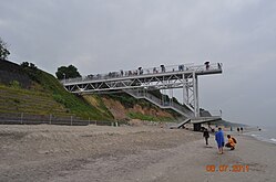
Beach bridge with viewing platform in Hoff
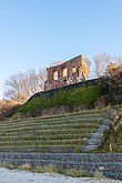
Church ruins Hoff seen from the beach

New Church of Hoff
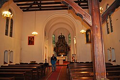
Altar of the church ruins in the new church in Hoff
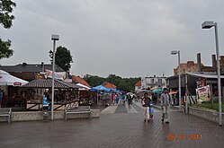
Promenade Hoff - from ruins to mansion (hotel)

View from the beach from the platform


.jpg)

Development of the population
- 1910: 235
- 1924: 250
- 1933: 199
- 1939: 201
Sons and daughters of the place
- Joachim Friedrich von Flemming (1665–1740), Electorate Chamberlain, General of the Cavalry and Governor of Leipzig
- Jacob Heinrich von Flemming (1667–1728), Polish and Electoral Saxon field marshal, real secret councilor and cabinet minister
Attractions
- Nikolaikirche with old altar of the church from the second half of the 15th century, which was abandoned in 1874.
- Picturesque ruins of the Nikolaikirche, a late Gothic village church from the second half of the 15th century.
.jpg)
Transport links

The place can be reached via public bus connections. Trzęsacz has a station on the municipality's own narrow-gauge railway Nadmorska Kolej Wąskotorówka , which has been running again in the season from Pogorzelica ( Fischerkaten ) to Gryfice ( Greifenberg ) since September 2013 .
Pomeranian legend
On the Baltic Sea beach near Hoff, a Swede is said to have been driven on an ice floe together with two cows . Instead of returning to Sweden, she is said to have preferred to stay in Pomerania, where she lived in Langenhagen and where she died of old age.
literature
- Johannes Kummerow: Yellowed leaves - From the church and parish chronicle of a community struggling with the sea . Verlag Martin Weichart, Hamburg 1988, 110 pages, ISBN 3-926033-03-7 (reprint of the Stettin 1924 edition).
Web links
See also
Footnotes
- ↑ Ludwig Wilhelm Brüggemann : Detailed description of the current state of the Royal Prussian Duchy of Western and Western Pomerania . Part II, Volume 1, Stettin 1784, pp. 36-37 .
- ↑ Friedrich Lietzmann: As a volunteer hunter with the skull hussars . Books on Demand GmbH; Norderstedt 2008, ISBN 978-3-940980-03-8 , p. 13 ( limited preview )
- ^ Wilhelm Hartnack : The coast of Hinterpommern with special consideration of the morphology (= 2nd supplement to the 43/44. Yearbook of the Geographical Society Greifswald). Greifswald 1926, p. 122.
- ^ Meyer's travel books: Baltic seaside resorts and cities on the Baltic coast , 4th edition. Leipzig and Vienna 1910, p. 135.
- ^ Meyer's travel books: German Baltic Sea Coast , Part II: Rügen and the Pomeranian Baltic Sea coast with its hinterland , 2nd edition. Leipzig 1924, p. 162.
- ^ A b Michael Rademacher: German administrative history from the unification of the empire in 1871 to the reunification in 1990. Grabberg.html. (Online material for the dissertation, Osnabrück 2006).
- ↑ TRANSODRA press review 36/2013 (PDF; 1.1 MB)
- ^ Literature sheet for the year 1841 (edited by Wolfgang Menzel). Cotta, Stuttgart and Tübingen 1841, No. 29 of Friday, March 19, 1841, p. 115, right column.
Coordinates: 54 ° 5 ' N , 15 ° 0' E