
Niechorze
| Niechorze | |||
|---|---|---|---|
 Help on coat of arms |
|
||
| Basic data | |||
| State : | Poland | ||
| Voivodeship : | West Pomerania | ||
| Powiat : | Gryfice | ||
| Gmina : | Rewal | ||
| Geographic location : | 54 ° 6 ' N , 15 ° 5' E | ||
| Height : | 0-18 m npm | ||
| Residents : | 927 (2009) | ||
| Postal code : | 72-350 | ||
| Telephone code : | (+48) 91 | ||
| License plate : | ZGY | ||


Niechorze ( German Horst or - officially until 1945 - Horst-Seebad ) is a fishing village and seaside resort in the Polish West Pomeranian Voivodeship .
Geographical location
Niechorze is located on the Baltic coast between the sea and Lake Eiersberg ( Liwia Łuża in Polish ) in Western Pomerania . Neighboring towns are the villages of Rewal ( German Rewahl ) in the southwest, Pogorzelica ( German Fischerkaten ) in the northeast and Lędzin ( German Lensin ) in the south. In the south, the two villages Groß- and Klein-Horst border on vast meadows, in the west and east on pine forests and in the south-east on the two-kilometer-long, partly covered, Eiersberger See. The Eiersberger See has an outflow into the Baltic Sea, which was called Liebelose and over which a road bridge leads towards the Fischerkaten.
history
Horst used to belong to a bailiwick. The place became known in the 15th century because a group of citizens of Greifswald and Stralsund had captured a hunting party of Duke Erich II in connection with a legal dispute . The contemporary Mayor of Greifswald, Heinrich Rubenow, wrote a report in verse about the scandal .
Horst originally consisted of the two villages Groß-Horst and Klein-Horst , which belonged to the cathedral chapter of Cammin. In 1784, Groß-Horst was a farming village with eight half-farmers , three cottagers and a schoolmaster and had 14 fireplaces. In addition to agriculture, there was fishing in Lake Eiersberg ( Liwia Łuża ). At the same time, Klein-Horst was a fishing village with 22 fishermen's cottages, a schoolmaster and 23 campfire sites.
The two villages were merged in the 1930s to form the seaside resort with the official name Horst-Seebad . The town owes its suitability as a seaside resort not least to high clay banks , which protect it from westerly winds.
Between the two world wars, mainly Berlin citizens had holiday homes built in the neighboring village of Pogorzelica ( German fishermen's hut), which can be reached via the Liebelose Bridge.
Towards the end of the Second World War , Horst-Seebad was occupied by the Red Army in the spring of 1945 . After the end of the war, the place was placed under Polish administration and was renamed after the expulsion of the German residents and was given the Polish name Niechorze . He belongs to the rural community of Rewal.

Seebad and its surroundings

Eiersberger See ( Liwia Łuża ) with the Liebelose drainage channel

Lighthouse at night

Coast from the lighthouse towards Kołobrzeg.

Fishing Museum

Parkowastraße
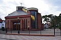
Stanislaus Church


Niechorze's structure as a fishing village was preserved. From the 1990s onwards, numerous hotels and holiday complexes were built, so that a holiday area was created that is about five to eight times the size of the old village.
Infrastructure and surroundings

Niechorze has an infrastructure with several hotels, guest houses, guest rooms in private houses and a camping site. There is a fishing museum on the eastern edge of the village. There is a modern sports field with artificial turf, a park with a few rides and the introduced 2009 bike sharing system "Rewal Bike System".
In the east of the village, the high steep bank that stretches from Dziwnówek ( German Klein-Dievenow ) along the Baltic Sea coast stops completely and turns into normal dune formation.
traffic

The village is about 2 kilometers north of the Wojewodschaftsstraße 102, which leads from Świnoujście ( Swinoujscie ) to Trzebiatów ( Treptow ad Rega ). The Greifenberger Kleinbahn of the city of Greifenberg ran from 1896 to 1905 as a narrow-gauge railway with a 750 mm gauge, since then with a 1000 mm gauge along the southern edge of the village. This is where the railway station, renovated with EU funds in 2011, is located on the route that is only used in museum operations.
Development of the number of residents and guests
| year | 1821 | 1870 | 1905 | 1910 | 1923 | 1925 | 1933 | 1938 | 1939 |
|---|---|---|---|---|---|---|---|---|---|
| Residents |
52 (Groß Horst) and 90 (Klein Horst) |
140 (Groß Horst) and 150 (Klein Horst) |
350 | 400 1873 bathers |
400 3000 bathers |
373 (community Groß Horst) and 265 (community Klein Horst) |
774 | 850 | 805 |
| year | 2006 | 2007 | 2008 | 2009 | 2010 | 2011 | 2012 | 2013 |
|---|---|---|---|---|---|---|---|---|
| Residents | 904 | 933 | 936 | 932 | 953 | 983 | 980 | 979 |
Personalities
- Paul Berndt (1879–1941), German naval engineer officer, most recently Vice Admiral (Ing.) Of the Reichsmarine , born in the then Pomeranian Groß-Horst


Attractions
Buildings, nature
- Fishing museum, with boats and fishing boats jacked up in the garden
- Shifting dunes , on the coast east of the village
- Butterfly house
- Wax figure museum
- Miniature park with models of Polish lighthouses, which are correctly arranged in a south-west-north-east direction according to their real location
Niechorze lighthouse
The landmark of Niechorze is the 45 meter high lighthouse built on the highest point of the steep wooded bank . Its construction, which cost a total of 56,600 thalers , was decided by ministerial decree of May 15, 1863, and it was put into operation on December 1, 1866. It is protected from underwashing by hydraulic protection devices. A steep staircase with 200 steps leads to his lantern (flashing light). From his gallery the visibility is around 50 kilometers in average visibility conditions. When visibility is particularly good, the Danish island of Bornholm, 85 kilometers away, can be seen on the horizon in the Baltic Sea .
See also
Web links
Footnotes
- ^ Roderich Schmidt: The historical Pomerania: people - places - events . 2nd edition, Böhler, Cologne 2009, ISBN 978-3-412-20436-5 , pp. 525 ff. ( Limited preview ).
- ^ Pomeranian and Rügische historical monuments . 2nd volume (Theodor Pyl, ed.), Greifswald 1867, p. 118 ff.
- ^ Heinrich Berghaus : Land book of the Duchy of Pomerania and the Principality of Rügen . Part II, Volume 5, p. 1058.
- ^ Addendum to the description of the Royal Prussian Duchy of Western and Western Pomerania (Christian Friedrich Wutstrack, ed.). Stettin 1796, p. 153, § 380 .
- ↑ Ludwig Wilhelm Brüggemann , Ed .: p. 52, No. 11 and No. 12 Detailed description of the current state of the Royal Prussian Duchy of Western and Western Pomerania . Volume 1, Stettin 1784.
- ^ Rewal Bike System , Gmina Rewal. Retrieved September 14, 2019.
- ↑ Alexander August Mützell: New topographical-statistical-geographical dictionary of the Prussian state, Volume 2 , 1821.
- ^ Heinrich Berghaus: Land book of the Duchy of Pomerania and the Principality of Rügen ... ; Dietze, 1870, accessed May 13, 2018.
- ^ Meyer's Großes Konversations-Lexikon , 6th edition, 1905, Part IX, p. 568.
- ^ Meyer's travel books: Baltic resorts and cities on the Baltic coast . 4th edition, Bibliographisches Institut, Leipzig and Vienna 1910, pp. 135–136.
- ^ Meyer's travel books: German Baltic Sea Coast . Part II: Rügen and the Pomeranian coast with its hinterland . 2nd edition, Bibliographisches Institut, Leipzig 1924, pp. 162–163.
- ↑ The community of Groß Horst in the former Greifenberg district in Pomerania , 1930s.
- ^ Website of the miniature park .
- ^ Heinrich Berghaus : Land book of the Duchy of Pomerania and the Principality of Rügen . Part II, Volume 5, pp. 1133-1135.